Parts of Texas are bracing for the possible challenging weather conditions due to the impacts of Beryl this week, which are causing hazardous commutes and heavy rains.
According to a weather report by the National Weather Service (NWS), Tropical Storm Beryl will bring life-threatening storm surges in parts of the coast of Texas, especially in areas in Padre Island National Seashore to Sabine Pass.
The forecast advises that people in the affected areas should keep alert for the latest weather information and advisories this week, including evacuation orders.
Considering the weather impacts, people in the affected areas should keep alert for flooding concerns. Low-lying communities and flood-prone areas can experience potential floods.
Beryl Potential Weather Impacts: Where Will Challenging Conditions Unload?
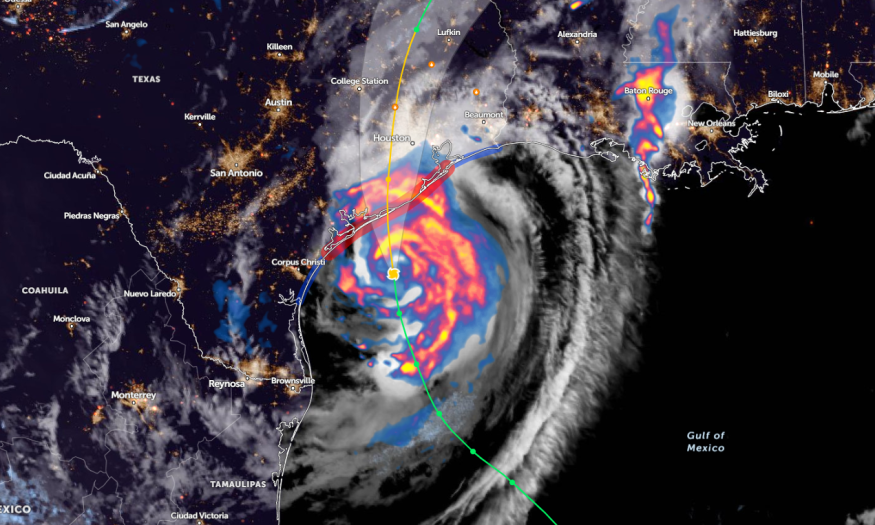
According to a weather report published on July 9, the forecast monitors the development of Beryl. This storm is expected to strengthen and bring poor weather conditions to parts of the U.S.
Beryl is forecast to make landfall in eastern Texas on Monday morning. The main weather risks are the following this week:
- Flash floods
- Damaging winds
- Flooding
- Heavy rains
- Storm surge
With the weather concerns, people should stay alert for evacuation orders or advisories, particularly for areas near rivers and coasts.
On Monday, the latest key message from the NWS warns of damaging hurricane-force winds in the Texas coasts. Homeowners are advised to stay alert for Hurricane Warnings from Baffin Bay to San Luis Pass.
Other concerns are flash floods and urban flooding, affecting portions of the middle and upper Texas Gulf Coast. Additionally, beachgoers should expect rip currents and dangerous beach conditions.
Meanwhile, areas in the Gulf Coast and Florida can experience rounds of heavy rains.
Beach hazards are likely in the following areas:
- Brownsville
- Corpus Christi
- Port Arthur
- New Orleans
- Panama City
- Tampa
- Cape Coral
Through Wednesday, Beryl can potentially unleash the following risks:
- Flooding rainfall
- Coastal inundation
- Damaging winds
- Power outages
The weather impacts can unload in the following areas:
- Houston
- Corpus Christi
- Little Rock
- St. Louis
- Indianapolis
- Detroit
In Little Rock, potential rainfall is likely in Arkansas on Monday and Tuesday. Residents can expect flash floods and river rises due to an excessive rain outlook.
On Tuesday, homeowners should watch out for flash floods and travel delays, with a risk of tornadoes. The areas with potential risks can be unloaded in the following:
- Peoria
- St. Louis
- Tulsa
- Memphis
- Jackson
- Alexandria
- New Orleans
- Memphis
- Nashville
- Louisville
- Indianapolis
On Wednesday, frequent downpours and travel disruptions are likely in the following areas:
- Springfield
- Little Rock
- St. Louis
- Indianapolis
- Toledo
- Detroit
Storm Impacts: How Can People Keep Safe From Flooding?
The latest weather information warns of challenging weather outlooks and conditions in Texas and the Southeast. As hurricane season begins, it is advisable to store emergency supplies, including the following:
- Canned goods and canned opener
- Extra clothes
- Bottled water
- Battery-powered radio
- Medicine kits
For more similar stories, don't forget to follow Nature World News
© 2025 NatureWorldNews.com All rights reserved. Do not reproduce without permission.


