A National Weather Service (NWS) forecast warns of damaging winds and flash flood concerns in the ArkLaTex region. Commuters can likely experience slower commutes, especially since many Americans are expected to travel this weekend. NWS also raised concerns about a severe weather potential in the Upper Midwest, with a chance of moderate to heavy rain.
In addition, an advisory by the NWS Weather Prediction Center monitors the return of heat in parts of the Great Plains and Texas. Meanwhile, residents in the Northeast and Mid-Atlantic can anticipate cooler-than-average temperatures.
Weather Conditions in the ArkLaTex region
According to a weather report by the NWS Weather Prediction Center for June 27 to June 30, residents in the ArkLaTex region can anticipate possible damaging winds and flash floods this week. Severe thunderstorms are likely in the Midwest and Central Plains this late week. From the southern Plains to the Southeast, there is a chance of dangerously hot conditions this weekend.
In addition, NWS Austin / San Antonio reported that a westward-moving outflow boundary would help develop a few showers in eastern and northern Williamson County. Residents should watch out for moderate rainfall and wind gusts reaching 30 mph. The forecast also noted another hot and humid day this late week, reaching the upper 90s to lower 100s. Additionally, heat indices can reach 105 to 110 range through the middle of the week. Next week, homeowners can expect a hazy sky outlook on Monday or Tuesday due to Saharan dust.
In Arkansas, NWS Little Rock reminded commuters and outdoor enthusiasts of a heat risk in the region this late week. While there is a chance of relief on Sunday due to a rainy outlook, residents should avoid prolonged exposure to unusual heat, especially next week.
Furthermore, the forecast monitors the development of a ridge of high pressure from the southern Plains to Arkansas. On the weekend, a rainy outlook is likely.
For Kansas City residents, dry and seasonable temperatures are expected to return. On Friday, homeowners can anticipate a thunderstorm condition, with a chance of heavier rainfall and severe storms.
Meanwhile, NWS Chicago reveals scattered showers and thunderstorm chances can unload this Saturday. There is also a chance that storms can unleash strong winds, flooding risk, and hail concerns.
Read also: Biden Vs Trump Debate: Why Climate Policy Is Crucial To Discuss Amid Global Warming Problems
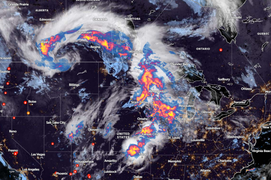
Central U.S. Weather Forecast: What Can People Expect?
According to a June 28 weather report, flooding and rounds of severe weather could persist in the central U.S. next week. The main concerns are the following:
- moderate to major flooding
- road closures
- flooded fields
- flooded roads
The forecast shows areas at risk are the following areas:
- Minneapolis
- Sioux Falls
- Omaha
- Des Moines
- Peoria
- Kansas City
- St. Louis
This Friday, commuters should keep alert for flooding concerns, damaging winds, and isolated tornadoes in the following areas:
- Cheyenne
- Denver
- Pueblo
- Garden City
- Omaha
- Wichita
- North Platte
- Kansas City
- St. Louis
- Springfield
- Chicago
- Duluth
Read also: Northeast Weather Forecast: Rounds of Rain, Thunderstorms to Bring Much-Awaited Relief From Heat
For more similar stories, don't forget to follow Nature World News
© 2025 NatureWorldNews.com All rights reserved. Do not reproduce without permission.


