According to a weather forecast, a major flooding risk is likely in parts of the Midwest, particularly from parts of Minnesota to Nebraska. Commuters can experience slower commutes and damaging wind hazards.
People near river or flood-prone areas are at risk of potential flooding rainfall this week, as severe storms can affect portions of the Midwest.
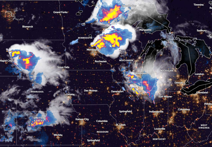
Storms have developed in southern WI and will continue to spread into northeast IL over the next few hours. A few storms could be strong to severe with the threat of damaging hail and possibly locally gusty winds. Heavy rainfall will also accompany the storms. #ILwx #INwx pic.twitter.com/68Ws2WpSg9
— NWS Chicago (@NWSChicago) June 25, 2024
June has experienced challenging weather conditions, from first-season heatwaves, isolated tornadoes, severe thunderstorms, widespread power outages, and flooding.
While astronomical summer is here, homeowners should keep updated with the latest weather reports, especially for people with travel plans.
For this week's weather, the main concerns are the following:
- Widespread damaging winds
- Flash flood
- Hail
- Isolated tornadoes
- Thunderstorms
Midwest Weather Outlook: Where Will Stormy Outlook Unload This Midweek?
According to a weather report published on June 25, residents should watch out for a stormy pattern in the Midwest and chances of severe thunderstorms. The last week of June will likely unleash road hazards and potential power outages.
Due to heavy rains, commuters can suffer from flooded roads and wet travel conditions. There is also a chance of road closures. Considering the weather forecasts, commuters should check the road conditions before leaving their homes.
In addition, portions of Chicago and Minneapolis, parts of Wisconsin, and southeastern Minnesota can anticipate a stormy outlook this week. This severe thunderstorm potential is packed with destructive wind gusts and hail.
In Chicago, a recent weather advisory warned of increased thunderstorms, which could impact portions of southern Wisconsin and northeast Illinois. The forecast noted that the hail can damage cars, while the torrential rainfall can result in flooding.
On Wednesday, the severe thunderstorms can threaten the following areas:
- Buffalo
- Burlington
- Pittsburgh
- Charleston
- Nashville
- Little Rock
- Atlanta
- Washington
- New York
- Boston
In Little Rock, residents can still struggle against unusual warmth and upper-level high pressure this early in the week. Most regions can experience temperatures in the mid to upper 90s. The forecast also reminded residents to stay alerted for excessive heat warnings.
An NWS advisory for New York reveals potential light showers can unload this week, easing the recent hotter temperatures. The strongest wind gusts can reach up to 46 mph. Highs can reach low to mid-80s.
Eastern US Weather Forecast
In the Eastern portions, there is no relief from scorching heat. The weather report shows another high humidity and heat surge this week, warning of potential heat-related health concerns.
On Wednesday, a hotter weather outlook is forecast in the following areas:
- New York
- Portland
- Boston
- Washington
- Virginia Beach
- Charleston
- Pittsburgh
- Knoxville
- Evansville
- St. Louis
For St. Louis residents, a weather forecast shows thunderstorms can unload late Tuesday, with a chance of strong to severe thunderstorms. Wind gusts can likely reach up to 60 mph. On Wednesday, unusual and dangerous heat will return.
For more similar stories, don't forget to follow Nature World News.
© 2025 NatureWorldNews.com All rights reserved. Do not reproduce without permission.


