Central U.S. residents can expect the much-awaited relief from challenging heat this week, according to a weather report by the National Weather Service (NWS). Commuters can also anticipate scattered showers and thunderstorms.
Many parts of the country have experienced severe thunderstorms and unusual heat. As summer begins, hotter temperatures can bring heat-related health concerns and advisories.
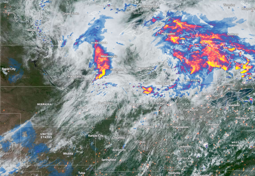
According to an NWS Weather Prediction Center report, showers and thunderstorms are likely in the region, bringing high rainfall rates and flash flood concerns in the Southwest. Meanwhile, severe storms are likely in the Upper Midwest, with a chance of tornadoes.
Weather in Central U.S.: Where Will Scattered Storms Unload?
An NWS report for June 23 to June 25 shows that temperature highs can occur in the Lower Mississippi Valley, Southeast, Southern Plains, west, Great Basins, High Plains, and California. Possible heat-related health advisories are likely in the affected areas.
In Mid-Atlantic, residents can anticipate record-high temperatures. While the weather outlook is ideal for outdoor plans this astronomical summer, homeowners should limit prolonged exposure to heat, particularly for older adults, people with medical conditions, children, and pregnant women.
The forecast also monitors the development of an approaching upper-level through, which could unleash cooler temperatures in the Southeast and Mississippi Valley. In other parts of the central U.S., commuters could anticipate the upper 90s and low 100s.
Another aspect of the weather is stormy conditions impacting portions of New England, Upper Ohio, and Tennessee Valleys. Potentially moderate to heavy rainfall is likely.
Meanwhile, a severe thunderstorm watch was issued in parts of Indiana, Iowa, Missouri, and Illinois. The advisory warned of tornadoes and hail conditions, with scattered gusts reaching 70 mph.
Other concerns are flash floods. The forecast raised concerns about the potential for flash floods and flooding in Iowa, Illinois, and southern Wisconsin.
Potential brief tornadoes can also threaten portions of northern Lower Michigan and northwest Saginaw Bay.
Considering the weather concerns in parts of the U.S., homeowners should stay updated with the latest weather information and limit outdoor plans as much as possible.
Southwest Gulf Weather Outlook
According to a weather report published on June 23, the forecast monitors potential tropical developments impacting the southwestern Gulf. Tropical developments and hurricanes are likely as hurricane season begins.
The forecast noted that the system has a high chance of becoming a tropical depression and affecting portions of Texas and Mexico. The main concerns are flooding rainfall, flash floods, and mudslides.
Whether the storm develops, it is essential to keep updated with the latest weather information. In the U.S., homeowners should stay alert for storm developments and severe thunderstorms, particularly for areas in Tornado Valley or areas prone to flooding.
Storing emergency kits can help mitigate the risks of being stranded due to hurricanes or severe thunderstorms. Additionally, staying updated with evacuation information is advisable.
Read also: Northeast, Midwest Deadly Heatwaves: Hotter Temperatures Expected to Improve This Weekend
For more similar stories, don't forget to follow Nature World News.
© 2025 NatureWorldNews.com All rights reserved. Do not reproduce without permission.


