People traveling to Indiana and Illinois should check the latest weather forecast, as a severe thunderstorm is likely this week. The primary risks are flooding, heavy rains, flash flooding, and travel hazards.
The late week of June is expected to unleash severe thunderstorms in parts of the country, including in the south-central U.S., this astronomical summer. Checking road and weather conditions is advisable to keep safe from changing weather conditions.
According to a weather report by the National Weather Service (NWS) for June 24 to June 26, severe storms are forecast in the Upper Midwest on Monday. Meanwhile, a potential slight risk of severe thunderstorms can threaten portions of the Northern High Plains.
In addition, scattered showers and thunderstorms can unfold in the Southwest. Other concerns are localized flash floods and high rainfall rates.
Indiana and Illinois Weather Forecast This Late June
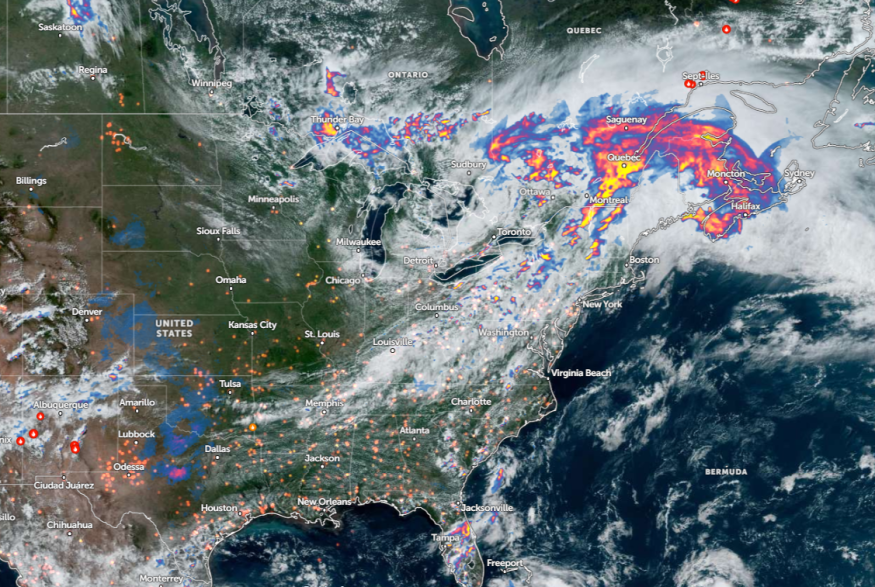
The weather report monitors the development of short-wave energy in southern-central Canada and northern-tier CONUS, which could unleash a thunderstorm activity in the Great Lakes Upper Midwest.
Residents in the Middle Mississippi Valley and Midwest can anticipate showers and thunderstorms on Tuesday. Additionally, there is a risk of severe thunderstorms in Iowa, northern Indiana, southwest Lower Michigan, Wisconsin, northern Illinois, Indiana, and Michigan.
Considering the weather threats this week, homeowners should watch out for flooding concerns in low-lying and flood-prone areas. Communities near rivers are also vulnerable.
According to an NWS Des Moines forecast, torrential rainfall is likely in Iowa, Minnesota, and South Dakota. The forecast warns of flooding in Upper Des Moines and Cedar River Basins. Other concerns are damaging winds and isolated severe thunderstorms from Monday to Tuesday.
In Chicago, the latest advisory monitors storm weather from Monday night to Tuesday. The line of slow-moving thunderstorms can move in parts of northern Illinois and northern Indiana, including at the Wisconsin state line.
Weather in Other Parts of the U.S This Late June
In other areas of the country, the forecast noted a broad and well-entrenched upper ridge centered in the Southwest and Southern High Plains. Additionally, low pressure is impacting portions of the Canadian Maritimes and Northeast, bringing possible thunderstorms and isolated showers.
Meanwhile, the remnants of Tropical Cyclone Alberto can still unleash monsoon-like conditions in the Four Corners region and Southwest, causing another threat of flash flooding.
In southeastern Arizona, there is the likelihood of excessive rainfall and flash flood concerns through midweek.
In other areas, scattered heavy showers and thunderstorms are expected in Central and Eastern New York into New England. A severe storm risk, packed with damaging, winds, can also be unloaded in southern New York and the Ohio River Valley.
Due to weather hazards in parts of the country, homeowners should keep updated with the latest weather information and limit outdoor plans when the weather becomes challenging.
Read also: Northeast, Midwest Deadly Heatwaves: Hotter Temperatures Expected to Improve This Weekend
For more similar stories, don't forget to follow Nature World News.
© 2026 NatureWorldNews.com All rights reserved. Do not reproduce without permission.


