The latest weather report reveals a moderate risk of excessive rainfall in Wisconsin and Minnesota, leading to power outages and hazardous commutes.
Other parts of the country also experience threats of heavy rains. In Texas, a developing tropical storm can bring flooding rains and gusty winds. Meanwhile, a wet weather outlook is likely in the north-central U.S.
Considering the weather outlook, keeping with the latest weather information or forecasts is advisable this week to avoid flooded roads or other road concerns.
Wisconsin and Minnesota Weather Outlook
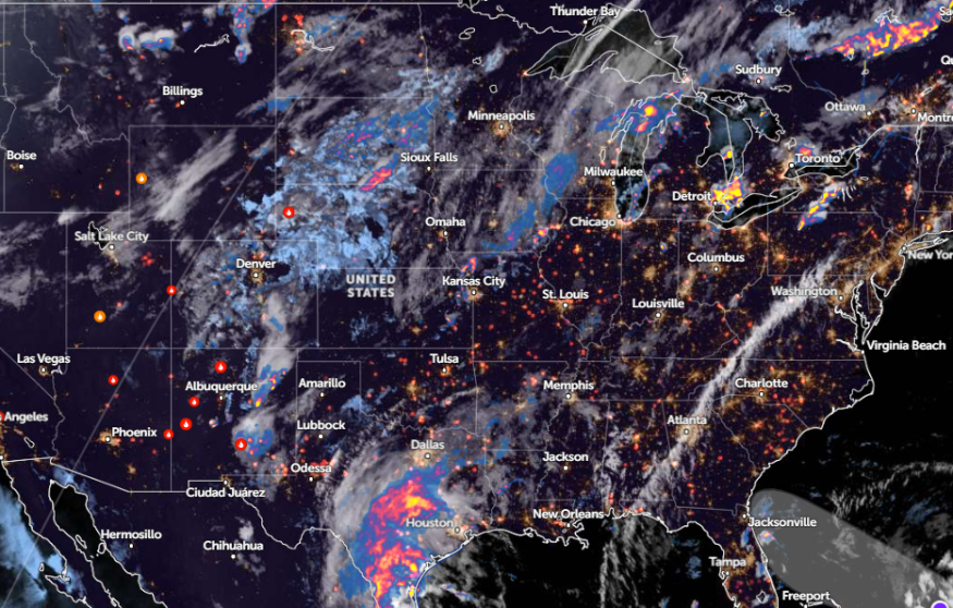
According to an NWS Short Range report for June 20 to June 22, the forecast monitors the likelihood of heavy rain in the north-central portions of the U.S. Possible thunderstorms are also likely on Thursday or Friday.
In addition, a moderate risk of excessive rainfall can unload in portions of eastern South Dakota. This wet weather outlook will spread over western Wisconsin and Minnesota on Thursday.
In a June 19 weather report, the forecast noted a weak front over northeast Missouri through southwest Wisconsin. Commuters should watch out for isolated non-severe storms in the region, particularly on Interstate 80.
In nearby areas, Iowa residents can also expect isolated showers and thunderstorms this week. In Minnesota, severe thunderstorms, bringing heavy rains and flooding, are likely.
NWS Duluth advised residents of floodwater risk in Little Fork River. Additionally, a seasonal and less humid weather outlook can unfold on Thursday, while scattered rains and increasing clouds can occur in central Minnesota.
In addition, an NWS Green Bay advisory shows periodic showers and a few thunderstorms affecting portions of Fox Valley and east-central Wisconsin. Lightning and heavy downpours are also possible.
Eastern U.S. Scorching Heat
While heavy rains threaten other parts of the U.S., the Eastern U.S. has braced for sweltering heatwaves. According to a weather report on June 20, over 135 million people are affected by heatwaves in the East.
As astronomical summer begins, residents should anticipate unusual heat or heat waves. The high temperatures are challenging for vulnerable populations, including older adults, children, pregnant women, and people with chronic diseases.
In this week's weather, a hotter weather outlook can hit the following areas:
- Chicago
- Louisville
- Memphis
- New York
- Boston
People with travel plans should monitor the latest heat advisories. It is best to limit prolonged exposure to scorching heat, especially in the afternoon. Additionally, checking for heatwave signs is advisable to avoid heat-related health concerns.
On Thursday, a dry condition, with little to no rainfall, is forecast in the following areas:
- New York
- Boston
- Richmond
- Raleigh
- Wilmington
- Columbia
- Atlanta
- Knoxville
- Pittsburgh
Homeowners should also check for signs of heat illnesses this week, especially in areas with scorching it. Additionally, there is a chance of heat relief on the weekend.
For more similar stories, don't forget to follow Nature World News.
© 2026 NatureWorldNews.com All rights reserved. Do not reproduce without permission.


