Due to a newly developed tropical storm, Alberto, challenging weather conditions are expected in parts of the Gulf Coast, Texas, and Mexico. Residents should watch out for flooding concerns, particularly in low-lying areas.
As the 2024 hurricane season begins, it is expected that tropical developments and possible hurricanes can unfold in the Atlantic and impact parts of the U.S.
10AM CDT June 19: #Alberto forms in the western Gulf of Mexico. Tropical storm conditions are expected today within the warning area. Alberto is a very large system with rainfall, coastal flooding, and wind impacts extending far from the center. For more visit… pic.twitter.com/GuFJfQVx6d
— National Hurricane Center (@NHC_Atlantic) June 19, 2024
The latest weather forecast monitors the development of Tropical Storm Alberto, which could unleash heavy rains, and strong winds. The warm waters and relatively low wind shear over the Bay of Campeche helped form this tropical storm.
Whether the storm becomes stronger or more severe, homeowners should keep updated with the latest weather information to avoid travel dangers.
Tropical Storm Alberto: Where Will Stormy Conditions Unload?
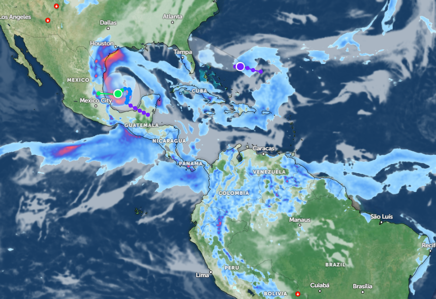
According to a weather advisory on June 19, Tropical Storm Alberto is expected to unleash heavy rainfall in Central America, including in South Texas and northeastern Mexico. This storm can also bring flash and urban flooding, especially for areas near rivers or flood-prone areas.
The weather report explained that Tropical Storm Alberto formed over the western Gulf of Mexico, warning of additional coastal flooding threats. Additionally, tropical winds can reach 40 to 60 mph.
In the latest key message, the advisory reveals that this storm is very large, with heavy rainfall and stronger winds. There is a chance that the tropical storm could make landfall on Thursday, June 20, in northeastern Mexico.
In addition to heavy rains, a National Hurricane Center advisory warns of life-threatening mudslides and flash floods this week, particularly in the following areas:
- Coahuila
- Nuevo Leon
- Tamaulipas
- Monterrey
- Ciudad Victoria
Commuters should be alert for flooded roads and slippery commutes due to the tropical storm. Additionally, homeowners should stay updated with the Tropical Storm Warning in affected areas to stay safe from stormy conditions.
NWS Corpus Christi shows a Tropical Storm Warning is still in effect in the region, particularly on the Texas coast from San Luis Pass to the Rio Grande. Additionally, a Flood Watch alert was issued for portions of South Texas through Thursday afternoon.
In North-Central and South-Central New Mexico, residents should watch out for a strong to severe thunderstorm potential.
Through Thursday, a weather report published on June 20 raised concerns about strong rip currents, travel delays, and strong rip currents in the following areas:
- Laredo
- Victoria
- Houston
Weather Preparedness: How to Keep Safe from Tropical Storms and Hurricanes
The latest weather report warns of Tropical Storm Alberto's developments this week, bringing hazardous commutes, and flooding concerns. This storm is packed with stronger winds and heavy rains.
Considering the weather outlook in parts of Texas and the Gulf Coast, homeowners should keep updated with the latest weather reports and limit outdoor plans.
In addition, storing emergency kits is advisable when the weather becomes severe or challenging.
For more similar stories, don't forget to follow Nature World News.
© 2025 NatureWorldNews.com All rights reserved. Do not reproduce without permission.


