People with travel plans should consider the weather forecast this week due to potentially severe thunderstorms in the central and eastern U.S., bringing heavy rains, flash floods, and isolated tornadoes.
In nearby areas, the forecast monitors the development of a low-pressure system in the Western Gulf of Mexico, warning of heavy to excessive rainfall in South Texas. Residents should stay alert for a flooding risk in areas near banks and small creeks.
Although astronomical summer is fast approaching this June, homeowners should still keep alert for the likelihood of severe thunderstorms, tropical development, and hurricanes
Weather in Kansas and Chicago: Where will thunderstorms unload this week?
According to a weather report published on June 19, the forecast monitors the daily threat of powerful thunderstorms over the central and eastern U.S. The main concerns are gusty winds, flooding, heavy rains, and tornadoes
Commuters should watch out for travel dangers, including flooded roads, and slippery commutes. The repeated downpours can help unleash flooding concerns, resulting in a major travel disruption.
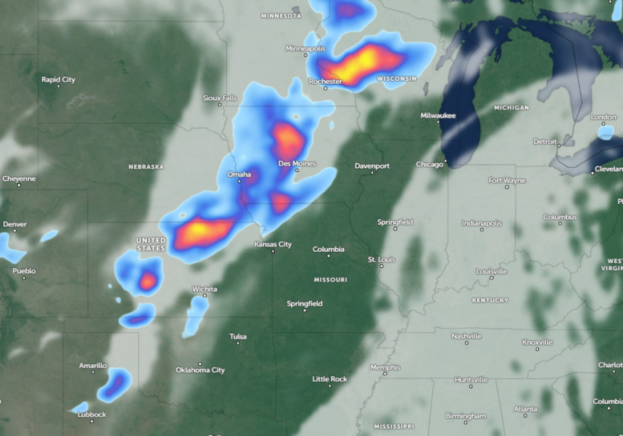
Rounds of rain and a flooding potential are forecast in the following areas:
- Fargo
- Duluth
- Minneapolis
- Sioux Falls
- Omaha
- Green Bay
- Thunder Bay
The latest weather advisory for Duluth warns of heavy rain along the North Shore and the likelihood of river rise, especially in Baptism River, Silver Bay, and Highway 61. Northern Minnesota can also experience possible flooding risk. Additionally, the forecast noted threats of gusty winds and brief tornadoes.
In Kansas City, residents can anticipate developing heat and humidity throughout the week. On Wednesday, thunderstorms are likely, and there is little to severe weather potential. Another concern is locally heavy rainfall in northwestern Missouri.
A widespread severe risk is forecast for midweek in parts of the Plains and Midwest, including Texas and Oklahoma. The main concerns are localized damaging winds, hail, and flash floods in the following areas:
- Dodge City
- Hays
- Amarillo
- Kansas City
- Des Moines
- Dubuque
- Chicago
- Milwaukee
In Chicago, travelers can still anticipate a continuing hot weather outlook this week. However, periodic chances for storms and showers are still likely. These isolated storms can unleash lightning strikes, gusty winds, and small hail.
On Thursday, possible severe thunderstorms can continue in Detroit, Buffalo, Syracuse, Pittsburgh, Scranton, Albany, Burlington, Portland, and Bangor.
In Dodge City, the forecast is monitoring the development of a line of thunderstorms in the region and southeast. Similar threats can unload, but heavy rain is the primary concern.
Read also: Florida Weather Forecast: Tropical Development to Unleash Local Flash Flood, Rough Surf This Week
Weather Preparedness in Chicago and Kansas City: How Can Homeowners Stay Safe?
The latest weather report raised concerns about flooding and tornado potential in the eastern and central U.S., warning of slower commutes and power outages. When conditions don't improve, it is best to stay at home until the weather improves.
In addition, homeowners can prepare emergency kits at home that will be useful when evacuation occurs or when they become stranded due to severe weather.
For more similar stories, don't forget to follow Nature World News.
© 2026 NatureWorldNews.com All rights reserved. Do not reproduce without permission.


