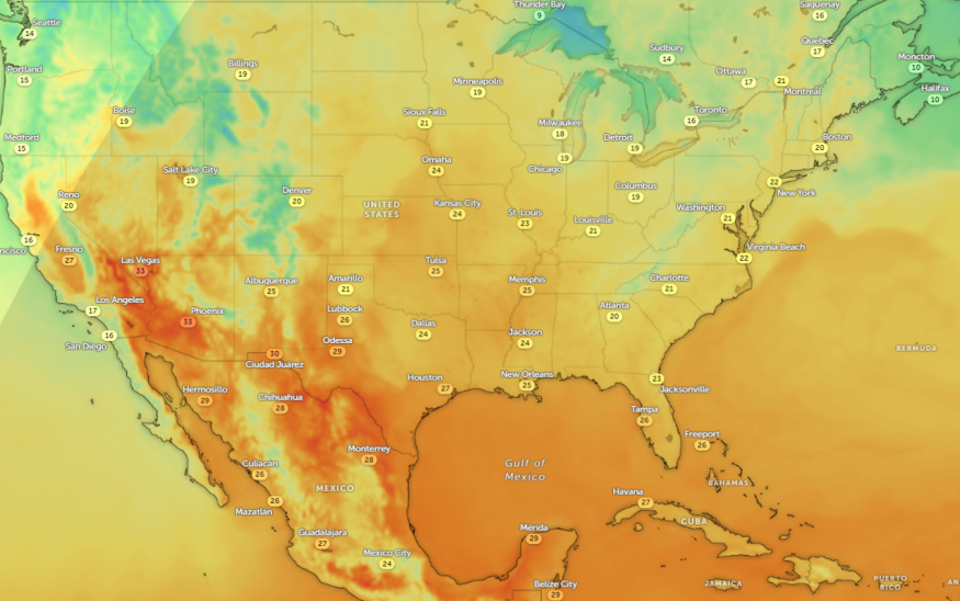
The latest weather report reveals that hotter temperatures are likely in portions of central and southern Texas, including Central California. Residents can notice unusual heat, which signals the arrival of summer in the U.S.
The National Weather Service (NWS) reported on June 2 that the forecast monitors an upper-level ridging over California and Texas. Due to high temperatures, homeowners can anticipate heat advisories.
In other portions of the U.S., the forecast monitors potential strong to severe thunderstorms in the Mississippi Valley into the Ozark Plateau and southern Plains on Monday. There is a chance of heavy to excessive rainfall in the region.
Additionally, portions of the Pacific Northwest can expect strong winds and heavy rain, as heatwaves affect California Central Valley and southwest U.S.
Weather in Texas: What can people expect?

The beginning of June is expected to unleash unusual heat in parts of the country, causing heat-related concerns. The vulnerable populations are older adults, people with chronic illnesses, outdoor workers, and children. Limiting outdoor activities is advisable during the height of intense heat.
According to an NWS Weather Prediction Center report on June 2, there is a threat of heatwaves in the southwestern portions this week due to potentially high-pressure ride build-up. The possible temperature highs can reach 100s in the Central Valley of California, and 110s in Las Vegas and desert areas.
Additionally, daily record high temperatures are likely to continue Thursday afternoon. Homeowners should be alert for signs of heat-related health concerns in the region, as the hotter temperatures can expand into the Great Basin.
For those looking for a cooldown or temperatures to ease, it is likely on Friday. Meanwhile, excessive heat threats can unfold in Nevada, California, and Arizona. Southwest residents can expect dry and unusual heat in midweek.
While the warming trend is on in Texas and other areas, the forecast noted that there is still a risk of thunderstorms in Texas. Additionally, the strongest thunderstorms are likely in the northern, and central Plains into the Mid-Mississippi Valley.
Weather outlook in other areas in the U.S
Furthermore, heavy rain potential and snowmelt can occur in the Intermountain Region on Monday. Homeowners can anticipate a slight risk of excessive rainfall in the said areas this early week. Other concerns are small stream flooding, flash flooding, heavy precipitation, and hazardous commutes.
People in low-lying communities in the Pacific Northwest can experience slower commutes or hazardous travel due to the weather, with a chance of heavy rains and localized flooding concerns.
People should stay updated with weather concerns, including heat advisories, to stay safe from heavy rains and unusual heat in the U.S. Limiting prolonged exposure to unusual heat is essential to keep safe from weather dangers.
For more similar stories, don't forget to follow Nature World News.
© 2025 NatureWorldNews.com All rights reserved. Do not reproduce without permission.

