Challenging weather conditions are likely in the High Plains to Mississippi Valley due to potential severe thunderstorms, causing thunderstorms, hail conditions, and isolated tornadoes.
The first week of June can potentially unleash troublesome weather conditions in portions of the south-central U.S., including the High Plains to Mississippi Valley. Recently, portions of the U.S. suffered from rounds of severe thunderstorms.
In this early week's weather, people should keep alert for challenging weather conditions, particularly isolated tornadoes. Residents should check for potential flooded roads and hazardous commutes.
In a weather report by the National Weather Service (NWS), the forecast warns of rounds of heavy rain and flash flood potential in south-central Texas. The NWS Weather Prediction Center also raised concerns about excessive rainfall and severe thunderstorms in the Great Plains and Mississippi Valley.
Weather in Plains and Mississippi Valley: Where will severe weather unload?
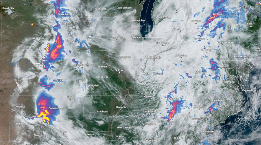
In the Plains and Mississippi Valley, the latest weather report published on June 2 revealed potential severe weather in the Upper Midwest, Midwest, and Plains next week.
According to a weather report, the potential severe weather concerns can occur in the following areas:
- Minneapolis
- Chicago
- Kansas City
- Dallas
- Memphis
- Charlotte
- Billings
- Seattle
- Portland
May unleashed busy, severe weather, causing significant damage to properties. Recent weather reports revealed widespread power outages and hazardous commutes. Last weekend's weather warned of severe thunderstorm threats in Kansas City, Hays, North Platte, Sioux Falls, Rapid City, Bismarck, Fargo, Minneapolis, Houston, Dallas, Lubbock, and Aberdeen.
In Kansas City, a possible storm can likely pass through mid-weel. particularly on Monday afternoon or Tuesday evening. Next week, homeowners should keep alert for strong to severe storms, and winds can likely reach up to 60 mph. East of I-35 can likely experience additional storms on Monday.
For Houston residents, the forecast shows that isolated to scattered thunderstorms can hit Houston this week, causing locally heavy rainfall and gusty winds. Additionally, there is a chance of flooding concerns, particularly in low-lying areas.
On Monday night, people should watch out for flooding downpours and hail, including localized damaging winds. According to a weather report, areas at risk are the following:
- Kansas City
- Oklahoma City
- Wichita
- St. Louis
- Wichita
- Dallas
- Shreveport
- San Antonio
- Houston
- Memphis
- St. Louis
The weather report reveals that isolated marginally severe storms can hit St. Louis on Monday, with potential large hail and damaging winds. Dangerous commutes can be likely this week, as a Dense Fog Advisory is present in the region.
Read also: Northeast Weather Forecast: Much-Awaited Cooler Air to Bring Relief from Recent Intense Heat
Preparing for severe storm potential: How can communities prepare?
The latest forecasts warned of severe storm potential in portions of the Plains to Mississippi Valley. People in affected areas should be alert for severe weather.
Additionally, homeowners should store emergency kits at home, which are helpful in challenging situations. This will be helpful also for the upcoming hurricane season.
For more similar stories, don't forget to follow Nature World News.
© 2025 NatureWorldNews.com All rights reserved. Do not reproduce without permission.


