Since Tropical Storm 'Victor' dissipated at the beginning of October, the Atlantic has been rather calm. Now that Wanda has stopped the calmness, AccuWeather experts are keeping an eye on another region for possible development.

Subtropical Storm Wanda
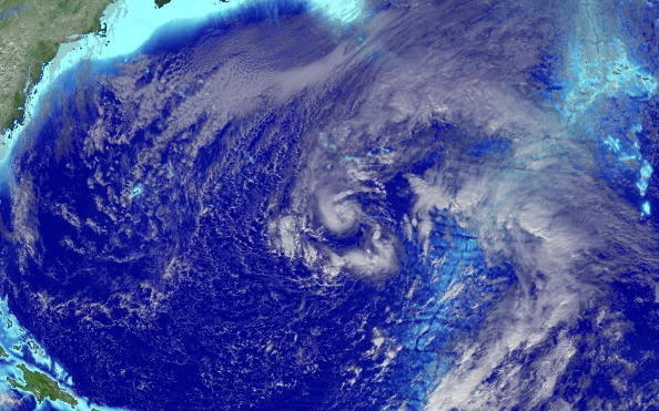
A nor'easter that hit the mid-Atlantic and New England earlier this week has now moved out over the northern Atlantic. However, its voyage isn't yet accomplished. What's remained of the storm has formed into Subtropical Storm Wanda, the last name on the Atlantic hurricane season's list for 2021.
Since Victor developed over the far eastern section of the basin on Sept. 29 and roamed the southern ocean until it dissipated on the 4th of October, the Atlantic has not named a storm.
Wanda was roughly 960 miles (1,540 kilometers) west of the Azores as of Sunday night. It had sustained winds of 50 miles per hour (85 kilometers per hour) and was traveling east at 8 miles per hour (13 kilometers per hour).
Wanda differs from previous storms this season, such as Ida and Henri, in that it is a subtropical cyclone rather than a tropical one, according to AccuWeather Meteorologist Lauren Hyde.
While tropical storms are more likely to form in warmer seas, subtropical storms are more likely to form in cooler waters.
Another distinction between the two kinds of storms is that subtropical storms are not as powerful as tropical storms or hurricanes, despite the fact that both may have severe effects such as strong waves, destructive gusts, and flooding rain.
Tropical Disturbance
"Environmental conditions are expected to sustain Wanda at subtropical storm strength for the next few days, but are not favorable enough to further strengthen Wanda significantly," said AccuWeather Meteorologist Thomas Geiger.
Luckily, Wanda is not predicted to affect land, but shipping interests should brace themselves for intense seas in its trail.
"Wanda is forecast to take a southeastward turn before tracking northeastward late Monday or early Tuesday towards cooler waters," Geiger noted.
Another tropical disturbance along the coast of Africa was being monitored by AccuWeather experts on the opposite side of the Atlantic. This tropical wave was positioned hundreds of miles southwest of the Cabo Verde Islands and had a low likelihood of developing during the following 48 hours.
This wave's formation would be unusual, according to Geiger, since tropical cyclones rarely form south of the Cabo Verde Islands in late October or early November.

Naming a Storm
If this wave becomes a tropical storm, it will be the first to be given a name on the World Meteorological Organization's supplementary name list, which was created to replace the Greek alphabet.
This new name list was created when the National Hurricane Center (NHC) was forced to use the Greek Alphabet to name additional storms during the 2020 Atlantic hurricane season.
The Greek alphabet will no longer be used by the World Meteorological Organization (WMO) because it creates a distraction from the delivery of danger and storm alerts and is possibly confusing. Adria is the first name on this new list.
Related Article : Developing Storm in Atlantic Coast Can Bring Strong Winds and Flooding in US Coasts
For more news, updates about Wanda and similar topics don't forget to follow Nature World News!
© 2025 NatureWorldNews.com All rights reserved. Do not reproduce without permission.

