People traveling this week should check the latest weather forecast in the Central U.S., as increasing storm chances are likely. Commuters should watch out for tornadoes and large hail in Mississippi Valley and mid-Altlantic.
Southeast and Central U.S. are no strangers to challenging weather conditions, including the following:
- severe thunderstorms
- isolated tornadoes
- scorching heat
- damaging winds
- flooding rainfall
- hail
As June ends, homeowners should watch out for another round of severe thunderstorms in parts of the country. The weather outlook also likely leads to road hazards, including flooded roads.
In other areas with a severe storm potential, a National Weather Service (NWS) advisory warns of flash flood risks in the Upper Midwest in the early week.
Central U.S. Weather Outlook: Where Will Challenging Weather Conditions Unload?
According to the NWS Weather Prediction Center, for June 25 to June 27, the forecast monitors the development of an upper-level ridge that will affect portions of the west-central U.S. This midweek, possible high temperatures are still expected in southeastern parts of the Lower 48, Plains, and Mississippi Valley, with low 100s in the central Plains.
Over the north-central U.S., the early summer brought heat-related stress, particularly for vulnerable populations without heating systems. Homeowners should keep alert for heat warnings or advisories, as heat could return this astronomical summer next month.
In the Central U.S., the forecast noted an upper-level shortwave in the region. Homeowners can anticipate increasing storm chances, easing the scorching heat.
Due to the enhanced severe weather risk, homeowners can encounter road hazards, power outages, and damaging winds. Limiting outdoor plans is advisable when weather conditions worsen this week.
On Wednesday, the forecast explained that the southeastward progression will help bring thunderstorm chances to the following areas:
- Very high wind
- Large hail
- Tornadoes
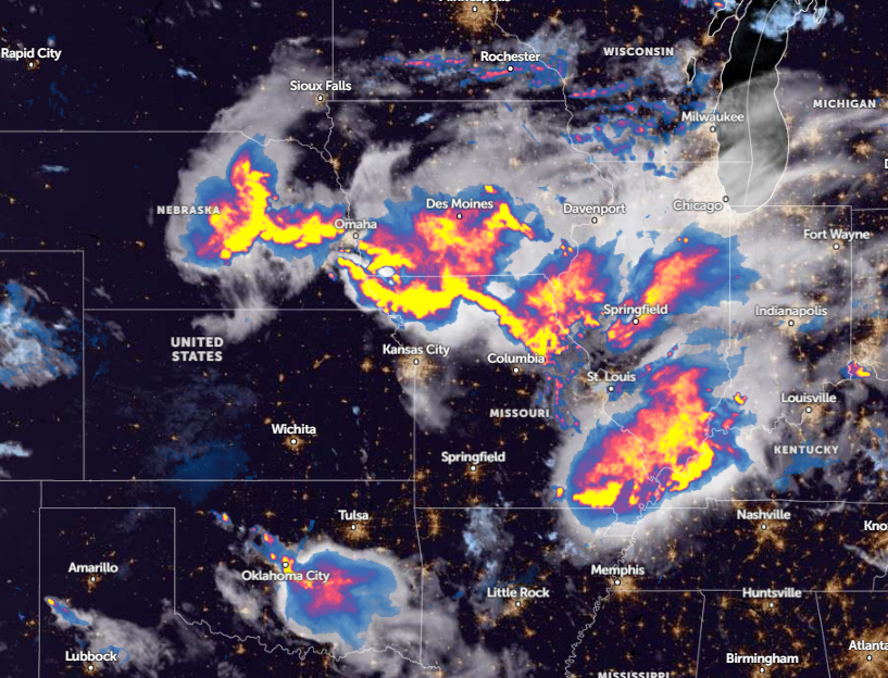
For Kansas City residents, stormy conditions will affect portions of Iowa and Nebraska. Commuters should keep alert for damaging winds and hail. Additionally, the severe thunderstorms resulted in tree damage in Howard and Cooper counties.
On Wednesday, the forecast explained that the southeastward progression will help bring thunderstorm chances to the following areas:
- Lower Mississippi Valley
- Middle Mississippi Valley
- Ohio Valley
- Tennessee Valley
- Mid-Atlantic
- Northeast
The forecast monitors the possible storm developments over NW Illinois for Chicago residents. Homeowners should keep alert for damaging winds, hail, and torrential rainfall.
Read also: Northeast Weather Forecast: Severe Thunderstorms to Bring Relief from Heat Surge This Midweek
Southwestern Weather Forecast
According to a weather report published on June 26, the latest advisory warns of thunderstorm conditions in the Southwestern U.S., causing lightning concerns and heavy rainfall. From Tuesday evening to Thursday, an uptick in thunderstorms can lead to local flash flooding and widespread lightning in the following areas:
- Salt Lake City
- Cedar City
- Flagstaff
- Santa Fe
- Durango
- Denver
- Rapid City
- Grand Island
For more similar stories, don't forget to follow Nature World News.
© 2025 NatureWorldNews.com All rights reserved. Do not reproduce without permission.

