Southeastern US residents can experience heavy downpours and flooding concerns due to a potential tropical development. Commuters should keep alert to the weather due to chances of hazardous travel.
As June ends, homeowners should keep updated for challenging weather conditions, from severe thunderstorms to the formation of tropical storms. These storms can unleash flooding rainfall, and dangerous road conditions.
According to a National Weather Service (NWS) report for June 23 to June 27, residents should watch out for heatwave concerns spreading over the Mid and Deep Southeast U.S. next week.
The forecast advises homeowners to monitor for tropical storms and hurricane forecasts. Additionally, staying updated with storm watches and warnings can potentially mitigate the risks of severe weather.
Tropical Development Impacting Portions of Southeastern U.S.
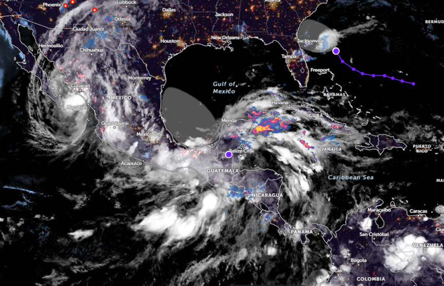
According to a weather report published on June 21, the forecast is monitoring the waters on the southern Atlantic coast due to possible tropical development.
Whether this storm will strengthen or develop, there is a possibility of showers, and thunderstorms affecting the following areas:
- Georgia
- Bahamas
- Northern Florida
- Carolina coast
Considering the weather outlook, the main concerns are gusty winds, heavy rains, and flooding. There is also a chance of locally severe thunderstorms, making it more challenging for homeowners and commuters.
In a weather report by the National Hurricane Center, the agency monitors the development of Tropical Depression Alberto. This tropical depression is forecast to diminish or dissipate and will not pose significant impacts in parts of South Texas and northeastern Mexico.
However, residents should still be aware of the likelihood of moderate coastal flooding, heavy rains, and mudslides in Mexican states such as Nuevo Leon, Tamaulipas, Monterey, and Ciudad Victoria.
Other concerns are swells due to Alberto, and rip currents near river or beach areas. For homeowners, checking the road conditions and forecasts will be the best option before leaving their houses.
From Thursday to the weekend, a wet weather outlook is expected in Jacksonville, Charleston, Daytona Beach, Wilmington, and Port St. Lucie.
On Friday, a rainy outlook can unload in Tampa, and Miami. On the other hand, sweltering heat will stay in Little Rock, Jackson, Montgomery, Raleigh, Nashville, and Atlanta.
In Little Rock, partly cloudy conditions are expected on Friday. Additionally, lows can reach the mid-60s to lower 70s, and highs could reach the 80s to mid-90s in some areas.
Staying Preparedness for Significant Rains and Flooding Concerns
In this week's weather, the latest information warns of a challenging weather outlook in parts of the Southeastern U.S., whether a tropical development will develop or weaken.
Because Hurricane Season has started, it is important to keep updated with the latest weather information, and associated risks this late week. Additionally, storing emergency supplies will be the best action when evacuations or disasters occur.
For more similar stories, don't forget to follow Nature World News.
© 2025 NatureWorldNews.com All rights reserved. Do not reproduce without permission.


