A wet weather pattern is likely in the Midwest and Northwest this early June, bringing potential stormy conditions. Homeowners can anticipate a wet weather pattern, causing possible travel hazards.
People with travel plans in early June should consider their daily commutes due to possible storms. In May, many Americans suffered from rounds of severe storms, which spawned flooding rainfall, hail, and isolated tornadoes.
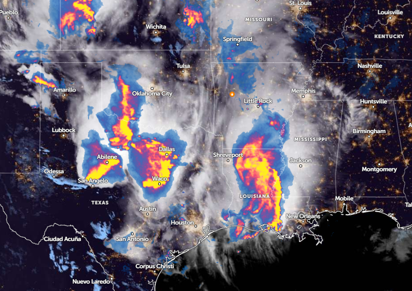
In a recent report by the National Weather Service (NWS), residents can anticipate strong to severe thunderstorms this week in the Southern Plains into the Lower Mississippi Valley, including in the Texas Gulf Coast. The main concerns are isolated tornadoes and severe wind gusts.
Weather in the Northwest and Midwest
The beginning of June will unload widespread rainfall in parts of the U.S., causing localized flash floods and windy conditions. According to a weather report published on May 31, the rainy outlook is likely in Seattle, Portland, Springfield, Medford, Kennewick, Spokane, Boise, and Missoula.
Homeowners can anticipate rain of two to four inches, particularly in the central Oregon coast and Washington Cascades. This can result in flooding concerns, particularly in low-lying or flood-prone communities. Homeowners should check for flood advisories before commuting.
On the weekend, rounds of rain and potential thunderstorms are expected in Minneapolis, Kansas City, Chicago, Memphis, Dallas, and Houston. Meanwhile, nice weather conditions can unfold in Boston, New York, Washington, Jacksonville, and Charlotte.
In the Bay Area, residents can anticipate cooler temperatures on Friday. For San Diego residents, a large area of high pressure will likely build next week, causing unusual warmups and high temperatures.
In other areas, Kansas City residents can expect thunderstorms and showers. While there is a low chance of severe weather, homeowners should keep alert for locally heavy rainfall in western Missouri and eastern Kansas.
Next week, widespread rainfall and gusty thunderstorms are forecast in Farago, Duluth, Green Bay, Des Moines, Grand Island, and Salina. Additionally, portions of the Midwest can anticipate threats of severe thunderstorms, and isolated tornadoes.
On Tuesday, a severe weather potential is likely in the following areas:
- Fargo
- Duluth
- Minneapolis
- Madison
- Sioux Falls
- Omaha
- Kansas City
- Peoria
- Ames
- Madison
The main threat is isolated tornadoes, and homeowners should keep alert for tornado advisories or warnings. In addition, the heat is expected to build from June 4 to June 7, bringing a significant warming trend in the following areas:
- Bend
- Redding
- Reno
- Fresno
- Las Vegas
- San Diego
- Phoenix
- Albuquerque
- Provo
- Boise
- Casper
- Denver
Read also: Northeast Weather Forecast: Much-Awaited Cooler Air to Bring Relief from Recent Intense Heat
Staying prepared for severe thunderstorms in June
The latest weather report warns of a wet weather pattern next week and severe thunderstorm potential in the Midwest. These weather conditions can likely result in power outages and hazardous commutes.
Homeowners should keep updated with the latest weather information before traveling, or checking the road conditions as possible.
For more similar stories, don't forget to follow Nature World News.
© 2026 NatureWorldNews.com All rights reserved. Do not reproduce without permission.


