Residents in the Southern Plains can expect an Enhanced Risk of severe thunderstorms in the Southern High Plains this week, bringing heavy rains and hail potential. Read here.
A National Weather Service (NWS) report shows that Southern Plains is expected to unleash potentially severe weather conditions, including rain and hail.
According to a report published on May 31, additional storm risks are likely in the Central High Plains and Mid-Mississippi Valley on Friday. Recently, the forecast also warned of thunderstorm potential in the central and southern Great Plains.
Additionally, the NWS Weather Prediction Center warns of a weather pattern in the mid-sections of the country, bringing rounds of thunderstorms, heavy rains, and severe weather.
Southern Plains weather outlook: where will severe weather unload?
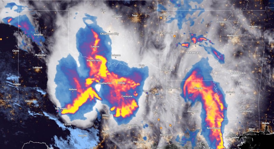
According to a weather report for May 31 to June 2, people should be alert for an enhanced threat of severe thunderstorms in the Southern Plains this week. There is a risk of severe thunderstorms in the Central and Southern High Plains.
Furthermore, there is a risk of challenging weather conditions in the Lower Mississippi Valley on Thursday or Friday. Meanwhile, Lower Mississippi Valley and Southern can expect a poor weather outlook on Saturday.
The primary risks are wind gusts, hail conditions, frequent lightning, and severe thunderstorms, including localized flooding or flash floods. People in low-lying areas, including near rivers or streams, are vulnerable to potential flooding concerns.
The forecast also monitors developing a second area of severe thunderstorms in the Southern Plains and Lower Mississippi Valley. According to a weather report, the SPC reported a risk of severe thunderstorms in the Lower Mississippi Valley and Southern Plains from Friday through Saturday.
On the weekend, homeowners should stay alerted for severe thunderstorm potential and showers. The main risks are frequent lightning, tornadoes, wind gusts, and thunderstorms. The forecast warned of thunderstorms and showers in the Upper Great Lakes, Ohio Valley, and Upper Mississippi Valley in the Upper Midwest.
NWS San Antonio and Austin reports possible damaging winds and large hail this week, particularly in the Hill Country and Interstate 35 corridor. There is also a potential risk between San Angelo and Valera. Meanwhile, Houston residents should keep alert for the next round of storms in the southeastward, including in the Brazos Valley and Piney Woods region.
Severe weather potential is likely in Houston this week, including in the eastern Harris Country. Residents should watch for damaging winds, frequent lightning, and heavy rains.
Read also: Northeast Weather Forecast: Much-Awaited Cooler Air to Bring Relief from Recent Intense Heat
Severe weather threats: How can homeowners keep safe?
The latest weather reports warn of severe weather threats in portions of the Southern Plains this week, causing heavy rains and hail. People with travel plans should stay alert for challenging weather conditions, including in portions of the southern U.S.
Additionally, homeowners should store emergency kit supplies as much as possible, as the weather could be severe or challenging.
For more similar stories, don't forget to follow Nature World News.
© 2025 NatureWorldNews.com All rights reserved. Do not reproduce without permission.


