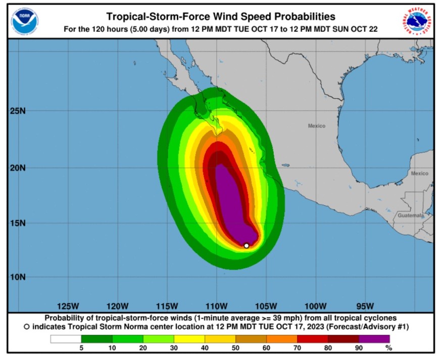
Meteorologists warned that newly formed Tropical Storm Norma could transform into a hurricane, noting that it will have an impact on Mexico.
Based on Norma's forecast, it may unleash strong rains over some portions of the United States.
According to the National Hurricane Center and Central Pacific Hurricane Center, Norma developed into a tropical storm at the Eastern Pacific.

Norma's Track
Meteorologists said that at 300 PM MDT (2100 UTC), the center of Tropical Storm Norma was spotted near latitude 13.2 North, longitude 107.3 West.
Norma is tracking the direction toward the west-northwest near 10 mph (17 km/h), and a west-northwest to northwest motion at a slightly slower forward speed is expected during the next several days.
Norma's maximum sustained winds are near 40 mph (65 km/h) with higher gusts.
Weather experts further observed that steady to rapid strengthening is possible, noting that Norma could become a hurricane on Wednesday.
Meanwhile, tropical-storm-force winds extend outward up to 140 miles (220 km) from the center.
The estimated minimum central pressure is 1004 mb (29.65 inches).
The NHC said that Norma is in a fairly conducive environment for intensification. Meteorologists observed that low vertical wind shear, warm sea surface temperatures, and favorable upper-level diffluence will likely lead to steady to rapid strengthening for the next few days.
Norma is seen to be moving west-northwestward at an estimated motion of 285/9 kt. This weather system is expected to turn more northwestward at a slightly slower forward speed during the next few days around the western periphery of a mid-level ridge.
Meanwhile, towards the end of the forecast period and as the system moves toward the Baja peninsula, there will be a notable divergence among the model suite.
Based on the forecast, increasing vertical wind shear and potential drier air intrusions could cause the system to gradually weaken towards the end of this weather system.
Read Also : Tropical Storm Lidia Expected to Intensify into Hurricane, Threatens Mexico With Rough Surf
Impact Towards United States
Aside from the possible effects towards Mexico, Norma is also seen to unleash rains over the US.
Meteorologists explained that steering breezes would eventually direct the system to the northeast and back toward the western coast of Mexico, perhaps as a potent hurricane.
Norma will likely begin to turn toward the northwest late this week or early this weekend.
It is expected that Norma will make landfall later in the weekend to early next week along the central west coast of Mexico. The weather system may pass near the tip of the Baja Peninsula first.
Aside from the torrential rains, floods and mudslides that are expected near the point of Norma's landfall, heavy rain associated with the weather system will also hit over the mountains across the interior.
Additional flash floods are also possible, meteorologists warned. They also expressed belief that some moisture as well as energy from Norma will survive the trip over the mountains in northern Mexico and then reach the US.
Weather experts said that there could be a gap in the rainfall triggered across Mexico and the US as it may take some time for the jet stream dip to re-energize the system.
Heaviest rainfall is likely to track across the northwestern part of Texas and the southwestern part of New Mexico as well as portions of Oklahoma before spreading into more of the central Plains.
Related Article : Tropical Storm Philippe: Another Disturbance Projected to Hit the US After Ophelia
Related Video:
© 2025 NatureWorldNews.com All rights reserved. Do not reproduce without permission.


