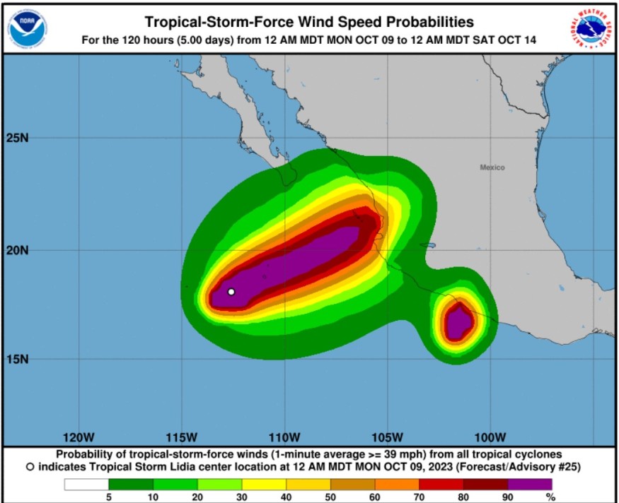
Weather experts said that Tropical Storm Lidia is threatening Mexico with rough surfs and high seas.
Based on the forecast, Lidia is coming nearer to the Mexican coastline and due to this, the high seas have already created rough surfs as well as strong rip currents. T
Meteorologists also warned that in the south, another tropical feature is targeting the southwest portion of the Mexican coastline early this week.
Lidia Projected to Become a Hurricane

According to the National Hurricane Center and Central Pacific Hurricane Center, Lidia is forecasted to become a hurricane, increasing the risk of strong winds, rainfall impacts, storm surge, and high surfs along the portions of the west-central Mexico Coast of Mexico.
Meteorologists said that at 1200 AM MDT (0600 UTC), the center of Tropical Storm Lidia was spotted near latitude 18.2 North, longitude 112.6 West. A microwave pass that was received just after the previous advisory has shown that the center was further south than estimated at 0300 UTC.
Lidia is tracking the direction toward the north near 6 mph (10 km/h). A faster northeastward or east-northeastward motion is expected until Tuesday.
Meanwhile, it was also seen in the forecast track that the center of Lidia would approach the Islas Marias and the coast of west-central Mexico on Tuesday, and it will move inland over west-central Mexico on Tuesday night.
Further, maximum sustained winds are near 70 mph (110 km/h) with higher gusts. On the other hand, strengthening is forecast on Tuesday, and Lidia is expected to be a hurricane when it approaches the Islas Marias and the coast of west-central Mexico.
Meteorologists said that tropical-storm-force winds extend outward up to 105 miles (165 km) from the center. Meanwhile, the estimated minimum central pressure is 990 mb (29.24 inches).
They said that Lidia is expected to produce rainfall totals of 4 to 8 inches with local maxima of 12 inches through Wednesday across the state of Nayarit, southern portions of the state of Sinaloa, and coastal portions of the state of Jalisco in western Mexico.
They warned that these rains would likely produce flash and urban floods, along with possible mudslides in areas of higher terrain near the coast.
Further, a dangerous storm surge is expected to produce significant coastal floods near and to the south of where the center makes landfall. Near the coast, it is forecasted that the surge will be accompanied by large and dangerous waves.
When it comes to winds, hurricane conditions are possible within the watch area by late Tuesday, with tropical storm conditions possible on Tuesday.
Tropical storm conditions are possible in the Tropical Storm Watch areas beginning Tuesday.
The swells, meanwhile, generated by Lidia will affect the west coast of Mexico and the Baja California peninsula for the next few days. These swells are likely to cause life-threatening surf and rip current conditions.
Read Also : Possible Storm Likely to Develop in Gulf of Mexico; Coastal Hazards to Impact Eastern Seaboard
Another Tropical Rainstorm Warning
Meteorologists also warned that another weather event would be worth monitoring over the upcoming days.
A tropical rainstorm has formed along the southern coast of Mexico and is on track to make landfall.
They warned that a cluster of thunderstorms located off the southwestern coast of Mexico is likely to become a tropical depression or storm at some point later this weekend.
Related Article : Eastern Pacific Weather: Tropical Storms Likely to Form Bringing Heavy Rain to Mexico
Related Video:
© 2025 NatureWorldNews.com All rights reserved. Do not reproduce without permission.


