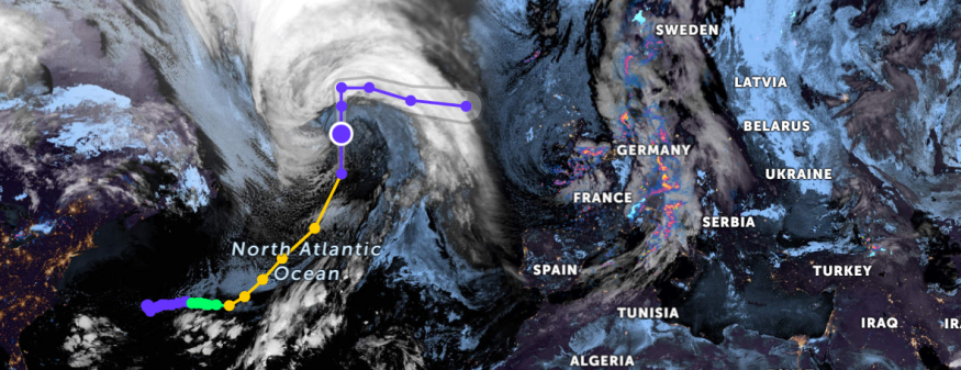
The latest weather forecast showed that Martin would remain a powerful storm in the Northern Atlantic that could impact portions of northwestern Europe, including Ireland and western, northern parts of the United Kingdom.

The storm could affect portions of Europe starting this weekend or next week.
Due to Martin's impact in the northern Atlantic, shipping lines could also be affected.
Residents in the affected areas should stay updated with the development of the storm.
Martin became a Category 1 Hurricane, reaching the 7th Hurricane in the 2022 Atlantic Season and emerged when Hurricane Lisa was set to unload flooding rainfall in Belize City and Guatemala.
Meanwhile, the National Hurricane Center (NHC) in the Martin Advisory 9 that large and powerful Martin in the northern Atlantic would become a post-tropical over the Central North Atlantic.
The early start of November in the Atlantic had two hurricanes.
Weather forecasts monitored the said hurricanes at the end of October, which could potentially transform into tropical depressions or storms.
The Hurricane Center reported that Hurricane Martin was located northwest of the Azores with 85 mph maximum winds.
Meanwhile, the latest update from AccuWeather on November 4, explained that Hurricane Martin would transition to post-tropical as it moves east of northwestern Europe this coming weekend.
The report also added that the Martin could affect areas in Portugal, France, and Spain, Scotland.
The storm could unload rain showers.
In the Weather outlook, AccuWeather reported that Martin would become a strong storm from Saturday evening to Tuesday morning.
According to the report, Martin would cause locally damaging winds, rough surf, and coastal flooding, especially in the northern United Kingdom and Ireland.
Areas affected could also expect flooding downpours.
Hurricane Lisa weather update
Hurricane Lisa was the 6th Hurricane of the Atlantic Season in 2022. In the latest forecast, the National Hurricane Center noted that Lisa had become a tropical storm.
The National Hurricane Center reported (700 AM CDT) that Tropical Storm Lisa continued to move to southeastern Mexico with heavy rains.
The tropical storm was tracked in the east-southeast of Ciudad del Carmen, Mexico (150 km).
Meanwhile, the report added that the tropical storm was moving west at ten mph (17 km/h).
The updated report added that the tropical storm recorded near 40 mph (65 km/h) maximum sustained winds and higher gusts.
The advisory said that Lisa would have a central pressure of 29.71 inches central pressure.
In addition, the report said that Lisa was not expected to reintensify as it moved to the Bay of Campeche. The storm would then again weaken to a tropical depression.
Based on the Key Messages Advisory 15, tropical storm Lisa could cause potential localized flash flooding in portions of northern Guatemala, southeast Mexico, and Belize.
In addition, the report added that the elevated water levels on Belize's coast are expected to diminish.
Hurricane preparations
The impact of hurricanes could result in heavy rains and strong to damaging winds. Martin could still unload heavy rainfall in portions of Europe.
Meanwhile, Lisa, which was downgraded to a tropical storm, would still cause flooding rainfall. It is still best to prepare for the storm.
Related Article : Hurricane Lisa Made Landfall Near Belize Coast that Could Cause Life-Threatening Storm Surge
For more similar, don't forget to follow Nature World News.
© 2025 NatureWorldNews.com All rights reserved. Do not reproduce without permission.


