A severe thunderstorm outlook is likely in portions of Oklahoma and Texas this week, resulting in heavy downpours and flooding conditions. People with travel plans should consider the weather's potential to prevent road dangers.
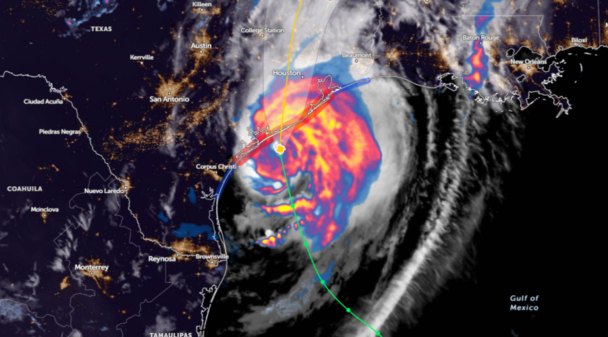
The National Weather Service (NWS) monitors the development of Beryl, which moves towards the middle Texas Coast. Commuters should keep alert for minor and isolated river flooding.
According to the forecast rainfall, a heavy rain potential is likely in the Mid-Mississippi Valley through mid-next week. The concerns are the following:
- Flash floods
- Urban flooding
Weather Conditions in Oklahoma City: Where Will Challenging Outlook Unload This Week?
In Oklahoma City, the NWS Weather Prediction Center warns of heavy rain potential and severe thunderstorms, packed with strong winds.
Considering the weather threats, commuters should keep alert for the latest flood watches and severe thunderstorm advisories.
According to a short-range forecast discussion for July 8 to July 10, severe thunderstorms can occur in Oklahoma City. A heavy rainfall potential can lead to slower commutes and hazardous travel in the affected areas.
In parts of Arkansas, residents should anticipate gusty winds and a period of heavy rain.
Another concern is tornado risk in other areas. In the weather report, the tornado potential is likely in the following areas:
- Memphis
- Little Rock
- Texarkana
- Shreveport
- Huntsville
- Houston
- Victoria
- Lafayette
On Tuesday, a rainy concern and tornado risk can unload in the following areas:
- Cincinnati
- Louisville
- Evansville
- Paducah
- Jonesboro
- Memphis
- Jackson
Weather in the Central U.S: What Can People Expect This Week?
NWS also warns of a poor weather outlook in the central U.S. and Mid-South. The main weather risks are the following:
- severe thunderstorms
- heavy rains
- flash floods
- flooding
In addition, scattered thunderstorms can occur in the Southeast this week, with a chance of flash floods.
Western US Weather Outlook: Where Will Dangerous Heat Unfold This Week?
According to a weather report on July 8, a dangerous heat outlook is likely in the Western U.S., from Washington to Arizona. The expansive heat can likely result in heat-related health concerns.
Another concern is wildfires, which could be exacerbated due to the following:
- lack of rainfall
- low relative humidity
- Warm conditions
Through Tuesday, a hotter weather condition can unload in the following:
- Portland
- Bend
- Reno
- Fresno
- Las Vegas
- Phoenix
- Cedar City
- Elko Boise
Read also: Scorching Heat in Western US: Record-Breaking Highs Likely to Unload From Washington to Arizona
Dangerous Weather Condition Safety Tips
The latest weather report raised concerns about possible severe thunderstorms this week, leading to dangerous weather conditions.
With changing weather outlook, it is best to stay alert for flood and road advisories, particularly in the affected areas.
In addition, emergency kits are essential in challenging weather conditions, including the following:
- Medicine kits
- Bottled water supplies
- Canned goods and canned opener
- Battery-powered radio
- Batteries
- Extra clothes
For more similar stories, don't forget to follow Nature World News
© 2025 NatureWorldNews.com All rights reserved. Do not reproduce without permission.


