A Fire Warning was issued for Otero County, New Mexico, by the National Weather Service (NWS) in El Paso, Texas on Tuesday, June 18. Amid the threat of a wildland fire dubbed "Salt Fire," evacuation orders are underway for multiple areas. The wildfire alert also asks the public to exercise precautionary measures, quickly evacuate, and follow the safety instructions of local emergency management officials.
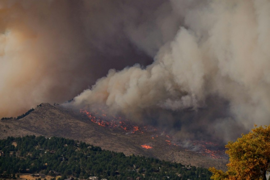
The Salt Fire was spotted in the vicinity of Bear Spring Road in New Mexico as of 4:00 a.m. MDT (local time) on Tuesday. While no fatalities or injuries have been reported, the weather service issued a mandatory evacuation of the said areas. In addition, the Salt Fire is burning along with the "South Fork Fire" located around the Mescalero Apache Reservation, near Ruidoso, New Mexico.
Although wildfires in the United States can occur throughout the year, they are mostly common during the wildfire season, where fire activity increases from May to September. This period of heightened risk from wildland fires, including bushfires and forest fires, coincides with the annual summer season. Earlier this year, US meteorologists forecasted an above-average summer season for some parts of the country.
Fire Warning Issued by NWS
In a social media post on the X platform on Tuesday, the NWS office in El Paso announced its issuance of a fire warning for the far northern Otero County. In its emergency bulletin, the weather service said the alert was in line with the request of the Mescalero Apache Tribe Emergency Manager. Specifically, Highway 70 Apache Summit and Ruidoso Downs are affected by the warning.
Fire Warning continues for portions of the Mescalero Apache Reservation. US-70 remains closed from Highway 244 to Ruidoso. Follow guidance from local officials. #nmwx #nmfire #SaltFire #SouthForkFire pic.twitter.com/o8GWAfjrYZ
— NWS El Paso (@NWSElPaso) June 18, 2024
On Tuesday morning, the "dangerous wildfire" was spotted around Bear Spring Road, which is located a few miles east of Highway 70. Due to the wildfire threat, evacuation orders are in effect for the following roads and areas in southern New Mexico:
- Snow Springs
- Chatto Bluff
- Fence Canyon
- Whitetail
- Chihuahua Well
- Fantasy Lane
- Summit Area
- Botella Road
- Apache Summit
Salt Fire and South Fork Fire
The ongoing blaze includes two wildland fires, called Salt Fire and South Fork Fire, as mentioned earlier. Based on updated reports from local sources, both wildfires have engulfed a total land area close to 20,000 acres as of Tuesday morning. The South Fork Fire and Salt Fire separately burnt an area of 13,921 acres and 4,876 with 0% containment, according to a report by the Village of Ruidoso on Facebook.
The NWS advises the public to avoid driving into areas with wildfire smoke and stated that an evacuation center for residents of the affected areas is available at the Community Center Gymnasium along 108 Central Venue in Mescalero, New Mexico.
In other parts of the country, especially in the drought-stricken western region, further wildfires are expected amid the US wildfire season, which according to experts, will peak in the coming summer months.
© 2025 NatureWorldNews.com All rights reserved. Do not reproduce without permission.


