The National Weather Service (NWS) shows severe thunderstorm risk in Colorado and Kansas, which could bring damaging wind gusts, large hail, and heavy rains. Due to potential road dangers, people with travel plans should consider the weather.
According to an NWS Weather Prediction Center report for June 14 to June 16, severe weather concerns are reported in the Northern and Central High Plains, including in the Northeast and Mid-Atlantic.
In addition, the forecast monitors the development of thunderstorm rounds in Florida and upper troughs in the Gulf Coast of Mexico and Southeast U.S. Homeowners should stay alert for a chance of intense thunderstorms and rainfall.
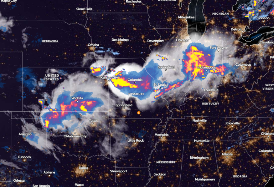
Meanwhile, excessive rainfall and flash flood concerns are likely in the Midwest, southeastern Iowa, northeastern Missouri, northwestern Indiana, and north-central Illinois.
Kansas City and Colorado Weather Outlook
According to a weather report, portions of Kansas City and Colorado can expect a severe thunderstorm potential, which could unload damaging wind gusts, heavy rains, and large hail.
Considering the weather risks, homeowners and commuters should stay alert for flooded roads, and slippery commutes. Checking the road conditions is advisable before having any plans this week.
The forecast also monitors the development of thunderstorm activity in the High Plains on Friday. The Storm Prediction Center warned of a slight risk of severe thunderstorms in eastern Colorado, eastern Kansas, and southwestern Nebraska.
In addition, scattered severe storms are expected to unload severe wind gusts and large hail in the Central Plains and Front Range on Friday. Meanwhile, a complex of storms was forecast in western Pennsylvania, including in the Northeast and Mid-Atlantic Coast.
Another concern is excessive rainfall in Iowa, north-central Illinois, and northeastern Missouri. Communities should stay alert for flooding concerns, especially in flood-prone or low-lying regions.
NWS Kansas City reports a severe thunderstorm warning in Liberty Gladstone and Smithville. Meanwhile, a severe thunderstorm watch was present in Missouri and Illinois. Additionally, strong and severe storms, including damaging hail and potential wind concerns, are likely in northeastern Missouri.
Large hail can reach a golf ball size, packed with damaging wind gusts and frequent lightning. A cluster of strong storms is expected in the south and east across northeastern Missouri.
Read also: US Heatwaves: 110 Million People Threatened by Widespread Heat from Chicago to Philadelphia
Gulf of Mexico Weather Outlook: Where will severe storm unload?
The forecast reports a tropical system in the Gulf of Mexico next week, bringing the potential development of rains and a stormy outlook. While the tropical downpours can ease the fire risk and drought in the region, flash floods and mudslides are likely in the following:
- Gumamela
- Honduras
- Nicaragua
- Costa Rica
- Cuba
Strong rip currents are also likely. To avoid potential road dangers, beachgoers should check the beach conditions before traveling. Next week, travel delays and flash flood risks are forecast in Houston, Laredo, Lake Charles, Alexandria, and New Orleans.
In Houston, a heavy rain potential is likely in the southwest Gulf of Mexico, and Southeast Texas. Residents should stay alert for rain and storms.
Read also: Great Plains, Mississippi Valley Weather: Severe Storms Possible to Unleash Hail, Rounds of Rain
For more similar stories, don't forget to follow Nature World News.
© 2025 NatureWorldNews.com All rights reserved. Do not reproduce without permission.


