A National Weather Service (NWS) warned of severe thunderstorms in Illinois and Wisconsin, causing wet weather conditions and flash flood concerns.
In other areas, a NWS report reveals that rainy conditions are likely in ArkLaTex and southern Arkansas. Residents should be alert for flash flooding.
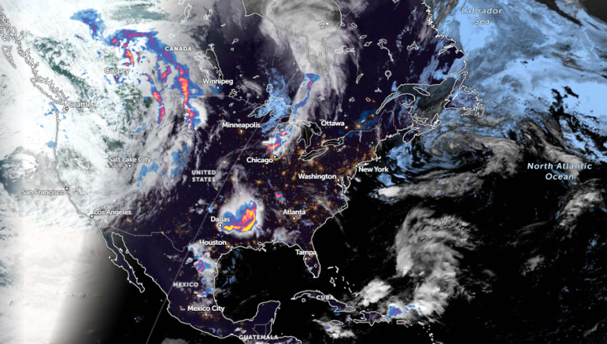
Meanwhile, a severe thunderstorm watch is likely in Texas and Oklahoma. The forecast also monitors the development of strong to severe thunderstorms in the Mississippi Valley into the Ozark Plateau and Southern Plains.
Wisconsin and Illinois Weather Outlook: Where will severe thunderstorms unload?
The NWS Short Range report for June 4 to June 6 monitors a front extending from the Upper Mississippi Valley to the High Plains. This week, severe thunderstorms and showers are likely in southern Wisconsin and northwestern Illinois.
A slight risk of severe thunderstorms is issued in the Mississippi Valley. Homeowners should watch for severe thunderstorms, wind gusts, hail, and tornadoes.
Additionally, residents in portions of Illinois and Wisconsin can expect a heavy rain potential. People in low-lying regions or areas are at risk of flooding, including in urban areas.
Meanwhile, north-central Texas and southeastern Oklahoma can experience threats of hail, as well as tornadoes.
In Chicago, the weather report monitors the likelihood of showers and storms on Wednesday. Widespread scattered showers are possible in northwest Illinois and near the Wisconsin-Illinois stateline. Additionally, stormy conditions can become strong or locally severe in the region.
Residents in the NW of I-55 can encounter scattered storms and localized flash floods. People with travel plans should check for stormy conditions, especially on Tuesday. Non-severe thunderstorms can occur in northern Illinois.
Poor weather conditions in Plains: Flooding rain and localized damaging wind gusts
In a June 4 weather report, the forecast warned of severe thunderstorms in the Plains, especially in southern Texas and Wisconsin. On Monday night, severe thunderstorms can unleash hail and flooding downpours in the following areas:
- Des Moines
- Kansas City
- Wichita
- Oklahoma City
- Dallas
- Waco
- San Antonio
- Shreveport
- Memphis
- Springfield
- St. Louis
- Peoria
- Chicago
For Kansas City residents, severe storms can occur on Tuesday in the region, with a chance of damaging winds and large hail. The stormy outlook can affect the Kansas City to Kirksville line.
In St. Louis, the latest weather report monitors the likelihood of additional storms and thunderstorms. Gusts can likely reach up to 60 mph. Commuters should also watch out for localized flooding in the region.
On Tuesday, severe weather risk can threaten portions of Fargo, Duluth, Des Moines, Chicago, Little Rock, Oklahoma City, Salina, and Green Bay.
Due to potential weather risks, people should stay alert to changing conditions. When the outlook worsens, it is best to stay home until the weather improves.
Read also: Eastern US Weather Forecast: Heavy Rains, Gusty Winds to Bring Slow Travel, Flooding Concerns
For more similar stories, don't forget to follow Nature World News.
© 2025 NatureWorldNews.com All rights reserved. Do not reproduce without permission.


