A National Weather Service (NWS) advisory is monitoring the potential development of a late spring weather pattern that could cause heavy rains and localized flooding in Oklahoma and Texas.
This May, Oklahoma, and Texas have been battered by rounds of severe weather, which have caused significant damage to properties and lives. Texas also recorded challenging heat concerns.
As severe weather threatens portions of the south-central U.S., people should keep up with the latest weather information, particularly in Texas and Oklahoma. When travel plans are unimportant, and there is a potential for severe thunderstorms, it is best to reschedule until the weather improves.
Oklahoma and Texas weather outlook this week
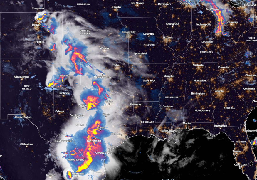
According to an NWS advisory, residents in the central U.S. can anticipate a weather pattern this week, which could cause flash floods and heavy rains. Additionally, thunderstorm conditions are likely in Southern Plains, Oklahoma, and Texas.
The report warns of severe thunderstorms in the region, including South Central Texas, Austin, and San Antonio. Residents can anticipate thunderstorms and showers moving to the east, and severe storms and hail are also risks. Commuters should watch out for thunderstorm watch this week.
Impactful thunderstorms are also possible in nearby areas, including Kansas, northern Texas, and eastern Nebraska. Homeowners should monitor possible severe thunderstorms and heavy precipitation. In Kansas, the recent forecast warns of chances of showers and thunderstorms on Friday.
There is a marginal risk of thunderstorms in Little Rock on Wednesday. Portions of central west and southern Arkansas may experience damaging winds and large hail. Meanwhile, low temperatures can reach in the upper 50s to upper 60s.
In southern Texas, residents can anticipate hot temperatures, including in Florida. There is also a record-high chance in the South and coastal Texas on Wednesday or Thursday.
In the Northern to Central High Plains, the forecast monitors the potential strong frontal boundary. Meanwhile, a potential thunderstorm outlook can occur in northeast Colorado, eastern Wyoming, and eastern Montana.
Read also: Northeast Weather Forecast: Much-Awaited Cooler Air to Bring Relief from Recent Intense Heat
Weather in other parts of the U.S: Threats of heavy rains and flooding
The forecast reveals the likelihood of increasing heat in the late week in the valleys of California. On the other hand, a widespread scattered shower on Tuesday can occur in Lower Lake into the Ohio Valley on Wednesday.
On Thursday, a weather report on May 29 raised concerns about a poor weather outlook, with a risk of hail and flooding downpours. A severe thunderstorm threat is expected in the following areas:
- Fargo
- Rapid City
- Sioux City
- Kearney
- Wichita
- Oklahoma
- Lubbock
- Dallas
Another aspect of the weather is the risk of flooding. People or communities near flood-prone areas should be aware of a rapid rise in waters. Additionally, motorists should be careful when driving on flooded commutes or slippery roads.
Read also: New York, Pennsylvania Weather Forecast: Heavy Rains Packed with Thunderstorms Likely This Week
For more similar stories, don't forget to follow Nature World News.
© 2025 NatureWorldNews.com All rights reserved. Do not reproduce without permission.


