Commuters traveling next week should consider the latest weather conditions, as destructive tornadoes and torrential downpours are all likely.
A recent report issued tornado alerts in portions of Nebraska, Kansas, and Colorado. In Kansas, the central and northern portions can experience severe weather outlooks packed with tornadoes, damaging winds, and large hail.
Additionally, a National Weather Service (NWS) advisory warns of moderate risk in Missouri, with a risk of damaging winds and heavy rainfall. Moderate risks are likely in central Kansas, eastern Kansas, northern Texas, and south-central Missouri.
Central states weather outlook: Where will severe weather unload?
According to a weather report, a potentially hazardous weather outlook can threaten portions of the central states this week. Homeowners can anticipate flash flooding, tornadoes, hail, and localized damaging winds.
Challenging weather conditions can also threaten portions of the Plains, Mississippi Valley, and the Midwest. The strong and damaging winds can cause slower commutes and dangerous road conditions, with a chance of hailstones.
The report warns of stormy conditions in Kansas City this week. A severe thunderstorm warning is likely in Boonville, New Franklin, and Pilot Grove. Commuters should consider the midweek weather outlook, with packing reaching 70 mph.
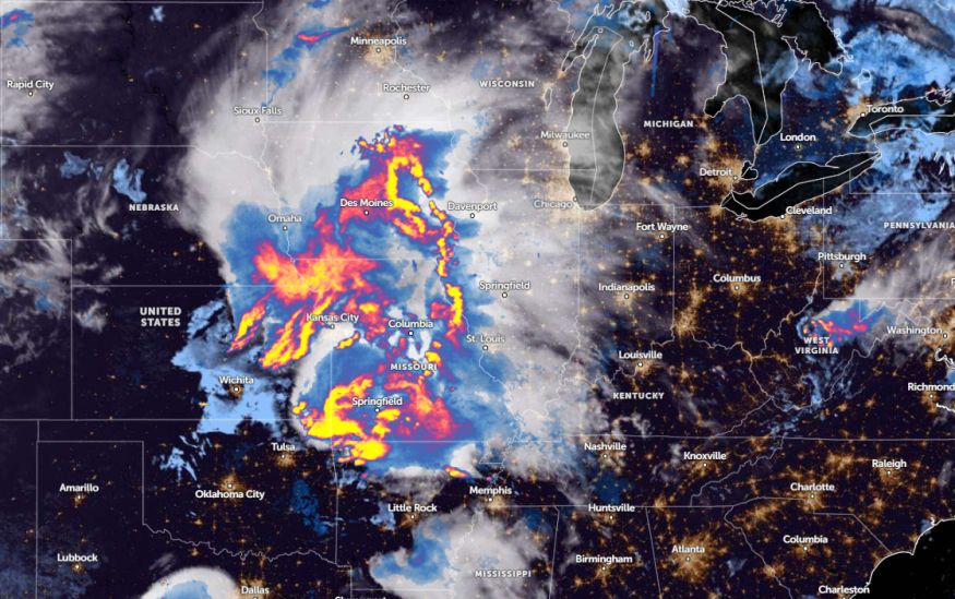
Additionally, a weather report on May 26 shows that a severe thunderstorm watch is issued in Iowa, Kansas, Missouri, and Nebraska. Meanwhile, a tornado watch was present in Kansas, Missouri, Oklahoma, Kansas, and Arkansas.
On Monday, the south-central U.S. can experience possible large hail, flash flooding, and isolated tornadoes. Severe thunderstorms can unload in Dallas, Tyler, Waco, and San Antonio.
NWS Austin / San Antonio advisory reveals that early season heatwaves are likely in the region, with potential record-breaking temperatures and increasing heat index values. Homeowners are advised to avoid prolonged exposure to scorching heat, including avoiding strenuous activity and drinking plenty of water.
On Tuesday, severe thunderstorms and localized damaging winds can threaten the following areas:
- Amarillo
- Lubbock
- Odessa
- Abilene
- Wichita Falls
- Odessa
- Waco
- San Antonio
- Waco
- Dallas
- Wichita Falls
- Oklahoma City
People in low-lying communities are vulnerable to flooding in the south-central U.S. this midweek. Commuters should check the road conditions before leaving or planning any outdoor activities.
In the Mid-Atlantic and Northeast, the latest weather report monitors the development of a warm and humid air mass. On Monday, residents can anticipate rounds of showers and thunderstorms.
Destructive tornadoes: Important weather safety tips this week
The latest weather report warns of potential destructive tornadoes and severe thunderstorms. Commuters can likely suffer from slower commutes, as torrential downpours are likely.
Due to potential weather threats, it is best to monitor the weather midweek. Staying updated with tornado advisories is essential, particularly when conditions become severe.
Furthermore, storing emergency kits is advisable this week to keep safe from challenging weather conditions.
For more similar stories, don't forget to follow Nature World News.
© 2025 NatureWorldNews.com All rights reserved. Do not reproduce without permission.


