The latest weather report warns of potentially dangerous flash floods in eastern Texas and western Louisiana this week, which could cause slower commutes and hazardous travel.
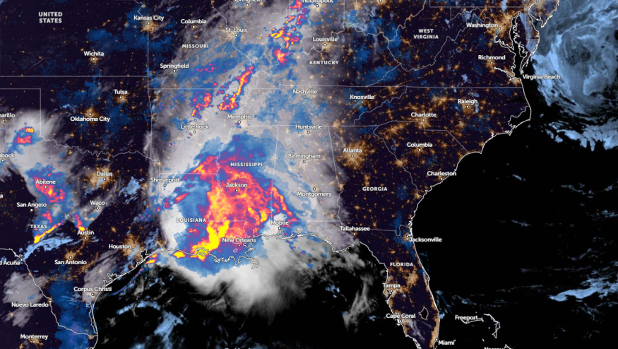
A National Weather Service (NWS) report on May 17 shows that heavy to excessive rainfall could unload in eastern Louisiana into central Alabama, including in the mid-Mississippi River Valley.
In addition, the advisory reveals that scattered severe thunderstorms could spawn tornadoes, damaging winds, and huge hail this late week. In Texas, the forecast warns of potential power outages in the region, including in Texas.
Weather in Louisiana this week: Where Will Severe Weather Unload?
According to a National Weather Service (NWS) report, dangerous and life-threatening flooding concerns could unload this week in portions of eastern Texas and western Alabama.
Homeowners should be alert in western Alabama and southern Mississippi for potentially significant heavy rainfall. Low-lying areas are vulnerable to flooding, and it is best to keep updated with flood watches.
The Upper Texas coast and parts of Louisiana could experience a risk of rounds of rain. In a recent Nature World News (NWN) report, the Gulf Coast States is threatened by potential isolated tornadoes and flash floods.
The NWS forecast also reports widespread thunderstorms and additional rainfall are expected in the Lower Mississippi Valley. In east-central Texas, a severe flash flood could occur amidst the risk of an expansive storm.
In addition to heavy rains, residents should watch out for severe wind, hail, and tornadoes. In the Southeast, the forecast monitors the development of thunderstorm conditions in the region.
On the other hand, a hotter temperature outlook is expected in portions of South Florida and Texas. Residents can experience unusual heat.
On Saturday, high temperatures could reach in the mid to upper 90s. The sweltering heat is forecast in the following areas:
- Orlando
- Tampa
- Melbourne
- Fort Myers
- Miami
- Fort Lauderdale
In Tampa Bay, the forecast shows a dry outlook and moderate drought this week. However, the drought concerns can ease due to a chance of rain this weekend.
For Jacksonville residents, the advisor is reminded to ensure heat safety by drinking more water and avoiding prolonged exposure to hotter outlooks. Similar to Tampa Bay, rain potential is forecasted for this weekend.
Read also: Texas Weather Forecast: Heavy Rains To Return This Weekend; River Flooding, Flash Flood Possible
Heavy Rains and Severe Weather Forecast: How Can People Keep Safe?
The NWS report warns of a challenging weather outlook in Louisiana and the Southern US. Limiting outdoor plans is advisable in parts of Texas and Louisiana, which could experience potentially severe weather and isolated tornadoes.
Additionally, the report reveals threats of tornadoes. People should check for tornado advisories, including watches and warnings.
Homeowners should consider storing emergency kits, which include medicines, canned goods, bottled water, a battery-powered radio, and flashlights.
For more similar stories, don't forget to follow Nature World News.
© 2025 NatureWorldNews.com All rights reserved. Do not reproduce without permission.


