The latest weather report reveals that a severe weather outlook is likely in the eastern and southern U.S. this week, causing potential threats of isolated tornadoes, thunderstorms, and hail conditions.
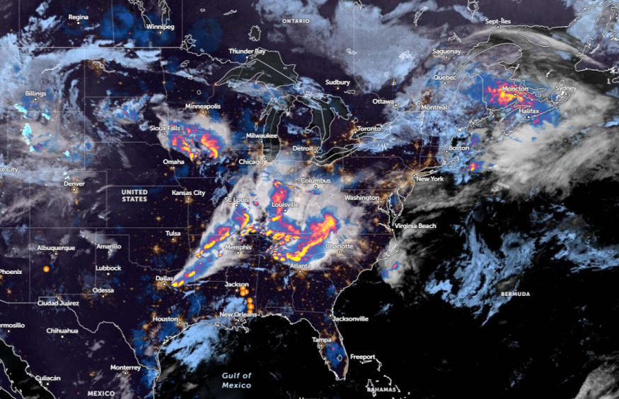
According to a report by the National Weather Service (NWS) on May 8, stormy conditions can unload in the south-central Kentucky and Middle Tennesee. Tornado watches were issued in portions of Mississippi, Missouri, Tennessee, and Arkansas.
Additionally, the forecast noted that severe weather could threaten the southern and central U.S. this week, causing potential strong tornadoes and dangerous winds.
Commuters are advised to keep updated with the latest severe weather forecasts in the region, including in areas with risks. When the weather outlook becomes severe, it is best to stay at home until the conditions improve.
Weather Conditions in Texas and Gulf Coast Regions
In a weather report on May 8, a rainy outlook is forecast in Jackson, Austin, San Antonio, Houston, Dallas, and Little Rock. Meanwhile, dry conditions will be likely in Lubbock, El Paso, and Odessa.
People in low-lying areas or near streams are vulnerable to flooding concerns. Homeowners should watch out for flood watch, particularly for flood-prone areas.
The NWS Weather Prediction Center reports that a moderate risk can occur in Kentucky, Ohio Valley, and Mid-MS Valley. The severe winds can significantly affect daily commutes, or cause damage to trees or power lines.
Recently, isolated marginally severe hail and strong winds were reported in northwest Illinois, eastern Iowa, and southwestern Wisconsin. In Kansas City, potential thunderstorms and stormy outlook can occur in the region, particularly in Miami County.
From midweek until the weekend, a dry outlook is likely in the following areas:
- Sioux Falls
- Des Moines
- Wichita
- Springfield
- Oklahoma City
- Lubbock
- Little Rock
- Dallas
Next week, a potential localized flash flood and renewed flooding can unload in San Antonio, Houston, Savannah, Jacksonville, and Tampa.
Areas in Texas can experience challenging weather outlooks, and commuters should stay updated with the latest road conditions.
Additionally, NWS Jacksonville reports that enhanced risk of severe storms can unload in the region, with concerns of isolated tornadoes, hail, and damaging winds reaching 50 to 70 mph. There is also a chance of frequent lightning.
In Nashville, the forecast warns of severe weather threats and flash flood concerns in the region. People should be alerted to multiple rounds of thunderstorms and heavy rain conditions
Weather Preparedness: How to Keep Safe from Severe Weather Outlook?
The latest weather report warns of challenging weather conditions in the central U.S. and parts of the Southeast. Commuters should watch out for dangerous road conditions due to heavy rains and damaging winds.
During a challenging weather outlook, it is advisable for households to store emergency kits. These kits should include battery-powered radios, canned goods, canned openers, bottled water supplies, and medicine.
Read also: Gulf Coast Weather Forecast: Widespread Damaging Winds, Lightning Strikes Likely to Threaten Midweek
For more similar stories, don't forget to follow Nature World News.
© 2025 NatureWorldNews.com All rights reserved. Do not reproduce without permission.


