Flash floods and isolated tornadoes are possible in the Southern Plains this week, causing potential flash flood threats and isolated tornadoes. Commuters should keep updated with the latest forecasts to avoid dangerous road conditions.
The National Weather Service (NWS) reported that a line of thunderstorms is likely in Iowa into northeastern Missouri this week. Residents in central Illinois can also face the same weather risks.
Additionally, NWS Tornado issued a Tornado Watch in Texas and Oklahoma City. Homeowners should stay prepared for nighttime tornadoes and stay alert for weather alerts.
Meanwhile, isolated flash flood risk is likely in the Mississippi River Valley, with potential stormy conditions. Potential scattered thunderstorms can impact portions of southern Wisconsin into central and eastern Iowa.
Severe Weather Forecast in the U.S.
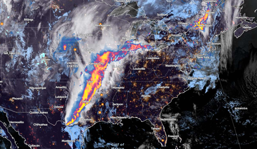
In a recent weather report, rounds of severe weather are expected in the Southern Plains and east-central Oklahoma. Rounds of excessive rainfall are likely in the Lower Mississippi Valley next week.
The forecast monitors the development of multiple disturbances and slow-moving upper-level troughs, which could impact portions of Central Plains. Meanwhile, the heaviest rain outlook could unload in the ArkaLaTex region.
Additionally, strong to locally severe thunderstorms can affect portions of the northeast and Midwest. The Storm Prediction Center reported an enhanced risk of severe thunderstorms in the eastern Southern Plains.
According to a weather report, over 50 million people are threatened by severe weather from the Gulf Coast to the Great Lakes, which could cause isolated tornadoes and heavy rains. In Oklahoma City, people should stay alert for severe weather outlook, with possible large hail.
Homeowners should also keep alert for flash flood threats, particularly for low-lying areas. Flooding risks can occur in flood-prone areas in the southern US.
Read also: Texas-Oklahoma Panhandle Weather: Stormy Conditions, Elevated Fire Concerns Likely this Week
Northeast Weather Outlook
The forecast shows that warmer temperatures are likely next week in the northeastern U.S. The higher temperatures can ease the recent frost outlook in the region, with temperatures reaching 10 to 20F above historical averages.
A warmer weather outlook is likely in the following areas:
- Detroit
- Buffalo
- Columbus
- Charleston
- Pittsburgh
- Washington
- Virginia Beach
- New York
- Boston
- Portland
- Burlington
- Ottawa
For New York, residents can anticipate high temperatures reaching 10 to 15 degrees, including in the NYC metro area. Meanwhile, Long Island and southern Connecticut can expect temperatures 5 to 10 degrees warmer.
In Boston, temperatures can change next week. The start of the week can bring warmer temperatures, and the outlook is expected to change to warmer in midweek.
Meanwhile, Chicago residents can anticipate showers and thunderstorms, with potential localized damaging winds and hail conditions. Homeowners should stay alert for localized flooding, including on Interstate 80.
In Northern IL, there is a chance of a line of severe thunderstorms, with possible localized large hail and brief tornadoes.
Read also: NWS Weather Forecast: Isolated Thunderstorms, Strong Wind Gusts to Hit Parts of Colorado, Utah
For more similar stories, don't forget to follow Nature World News
© 2025 NatureWorldNews.com All rights reserved. Do not reproduce without permission.


