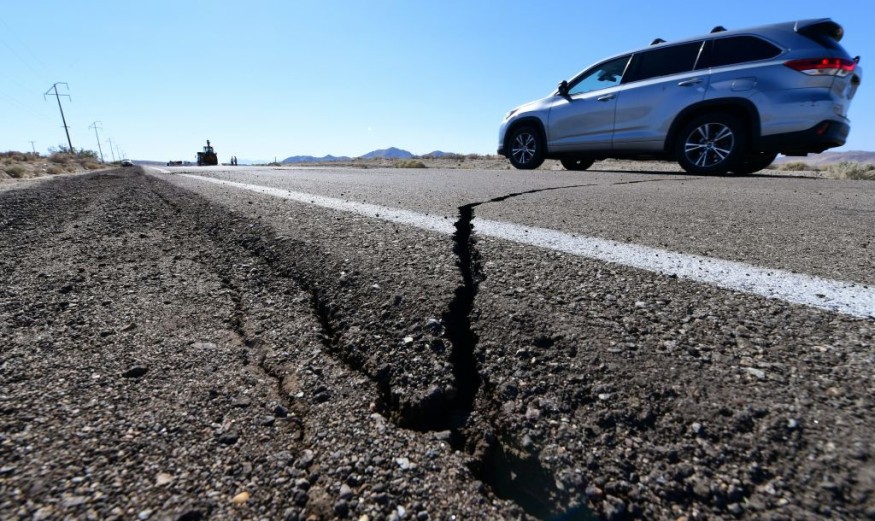
With fissures extending up to 15 kilometers through the streets of Grindavik, the likelihood of an Icelandic volcano erupting is much higher.
Fissures Open Up the Streets of Iceland
The Icelandic Meteorological Office issued a grave warning on Monday, indicating a substantial probability of an imminent volcanic eruption in Iceland's southern peninsula, despite a recent decline in seismic activity. Once reliant on fishing, Grindavik, now grapples with road fissures and structural cracks, transforming its landscape. The seismic unrest in this town of approximately 4,000 inhabitants, nestled within the Reykjanes Peninsula, resulted in numerous minor earthquakes causing damage to infrastructure.
Iceland 🇮🇸 declares emergency in anticipation of a large volcanic eruption, as over 3,000 earthquakes are reported.
— ❂ Yübbîę Umoh ❂ (@Yubbie007) November 14, 2023
Massive fissure splits a road apart in Grindavik...pic.twitter.com/LN9lpOkZUS
Matthew James Roberts, overseeing the meteorological office's service and research division, emphasized the precarious situation, describing the intrusive force as precariously poised, just beneath the Earth's surface. Uncertainty looms large as Roberts raises critical questions: Will an eruption occur, and what magnitude of destruction might ensue?
Evacuation orders were issued for the town's residents over the weekend, anticipating the imminent eruption of the Fagradalsfjall volcano. On Monday, a brief window allowed inhabitants a mere five minutes to retrieve their most cherished possessions, including livestock.
With Iceland harboring 33 active volcanic systems, a state of emergency was declared, prompting the establishment of shelters and aid centers in nearby towns. Vidir Reynisson, head of Iceland's Civil Protection and Emergency Management Agency, highlighted a 15-kilometer-long fissure as a potential eruption site, underscoring the omnipresent threat.
Evacuating Seismic Activity Prone
Residents of Grindavik, compelled to evacuate on an early Saturday morning, were granted a brief opportunity to revisit their homes and retrieve belongings come Monday. Car queues snaked for hours outside the evacuation perimeter, given mere minutes for entry. Urged by Iceland's emergency response unit, residents hurried to expedite the process.
Observing this scene, one could witness locals cramming their vehicles with prized possessions, ranging from furniture to artwork, and in a peculiar instance, even livestock.
Situated southwest of Iceland's capital, the Reykjanes Peninsula seismic hotspot stands as a prominent geological feature. Vidir Reynisson, heading Iceland's Civil Protection and Emergency Management Agency, noted a fissure stretching approximately 15 kilometers (around 9 miles) long. Experts believe an eruption could potentially transpire anywhere along this geological rift.
In March 2021, a fissure within the Fagradalsfjall volcanic system spewed lava fountains, extending 500-750 meters in length. This event persisted until mid-September 2021, characterized by multiple vents, gas emissions, and lava flows filling Geldingadalur and eventually reaching Meradalir valley.
Notably, three eruptions near Fagradalsfjall occurred in March 2021, August 2022, and July 2023, all distanced from infrastructure and populated regions, sparing direct impact on communities.
Sulfur Dioxide Detected
This week, two DOAS (Differential Optical Absorption Spectrometer) instruments were installed by IMO experts at Húsafell to detect sulfue dioxide levels. One instrument detected SO2 near the new graben between Sundhnúkagígar and Grindavík. Due to limited daylight, data analysis took time. Recent seismic activity might've triggered SO2 release from beneath Fagardalsfjall, influenced by magma pressure within the upper crust. DOAS placement near Grindavík aids in monitoring.
© 2025 NatureWorldNews.com All rights reserved. Do not reproduce without permission.


