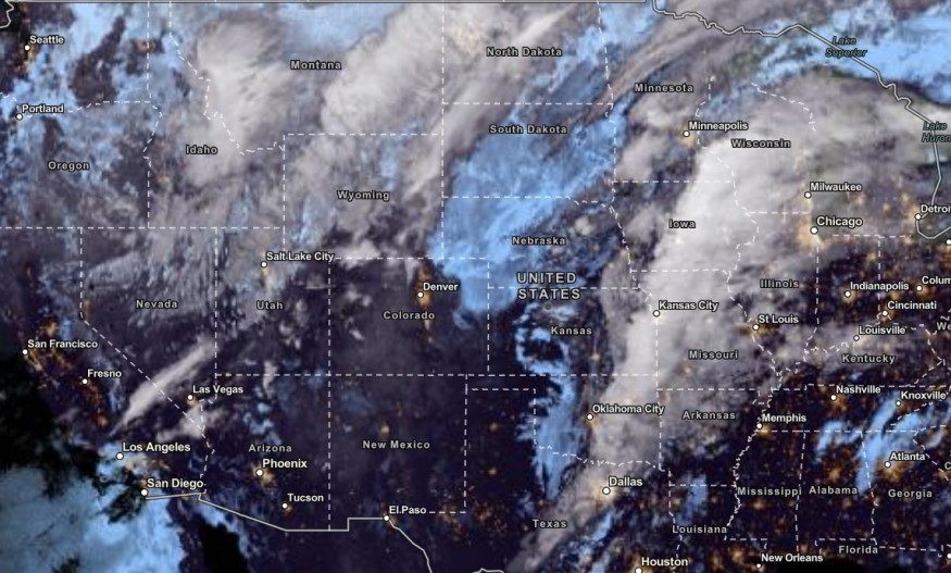
The National Weather Service (NWS) reported that thunderstorms and excessive rainfall could unload in the Southern Plains and Great Lakes this week, causing possible flash floods and travel dangers.
Motorists should check the weather due to enhancing rainfall in the region and anomalous high moisture. Low-lying areas are vulnerable to small to severe flooding depending on rain intensity.
🌧️🔴 There is a Moderate Risk of Excessive Rainfall today across parts of the Southern Plains as a multi-day heavy rainfall event unfolds. Numerous flash floods are likely, especially in the Moderate Risk area highlighted in red. pic.twitter.com/3sRQdyvvrZ
— NWS Weather Prediction Center (@NWSWPC) October 25, 2023
The advisory warned of powerful upper-level disturbance over the Southern Plains. This week, the main dangers are river flooding, heavy rains and thunderstorms.
Southern Plains, Upper Great Lakes in the US: Where Will Excessive Rainfall Impact?

According to the NWS, there is an unusual amount of moisture in the region that can trigger heavy rain and flash flooding. Homeowners near rivers and creeks should stay alert for rapid rise of water.
The Midwest, Plains and Great Lakes will experience a stormy pattern this midweek. Widespread heavy rains will also unload in parts of Central and Eastern Texas.
On Thursday, Southern Plains can anticipate increasing concerns about excessive rainfall.
The forecast warned residents to keep away from flooding roads or streets due to health dangers. In the Central US, residents can expect a blast of cold air and a stormy outlook.
The beneficial rain will ease the dry conditions as Central US recently experienced hotter weather due to the heat dome. On Friday, rainy outlook could unload in the following areas:
- Houston
- Minneapolis
- Chicago
- Dallas
- Kansas City
On the weekend, a pattern change to a warmer outlook will return in the following areas:
- Raleigh
- Atlanta
- Montgomery
- Jackson
- Dallas
- Lubbock
In Houston, the latest advisory warned of gusty southeasterly winds that could result in challenging marine and beach conditions. Beachgoers should check for life-threatening currents and waves.
Dangerous swimming will be likely due to the hazards of marine conditions. In the city, scattered showers will unfold in the late week.
⚠️Gusty southeasterly winds will continue to bring hazardous marine and beach conditions across the Upper Texas Coast today.
— NWS Houston (@NWSHouston) October 25, 2023
Stay weather aware. Stay Safe. Be cautious when swimming, especially near piers and jetties. pic.twitter.com/Rf1zmJPFTP
In Kansas, rainy and thunder conditions can likely hit the area before the end of the week. On the weekend, residents can anticipate chilly temperatures.
Meanwhile, Nashville can expect a big cooldown on the weekend. Early next week, there is a chance of widespread frost in the region.
Excessive Rainfall And Thunderstorm Safety This Week
Heavy rain to excessive rainfall is possible in the Southern Plains and Upper Great Lakes. As mentioned, the rain can trigger travel dangers for homeowners and commuters.
Next week, a frosty pattern could change the weather pattern. However, homeowners should still remain alert for flash floods and flooding. Here are important rainfall reminders.
- Homeowners should watch out for creek or river flooding. Excessive rainfall can quickly cause flooding.
- Motorists should stay careful while on the road. It is best to stay away from flooded roads or wait until the weather improves.
Stay updated with the latest forecast in Nature World News in November.
For more similar stories, don't forget to follow Nature World News.
© 2025 NatureWorldNews.com All rights reserved. Do not reproduce without permission.


