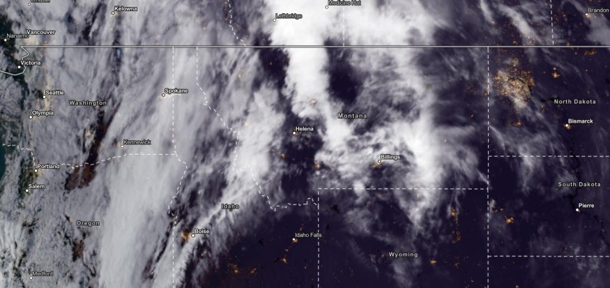
The latest weather forecast showed that high-elevation wet snow could unload in Montana and Idaho as the fall weather already begins in the US. As chances of snow unfold, colder weather is on the way.
The early beginning of October brought significant below-temperatures in parts of the US, including the Northeast and Midwest. The rainy outlook in the region eased the dry and drought concerns.
In the latest forecast, the National Weather Service (NWS) reported that dry conditions could continue in the continental US this week. Meanwhile, a wet outlook could unfold in the Upper Midwest and Pacific Northwest.
High-Elevation Wet Snow: What Can Residents Expect?

In October, people are excited about the arrival of snow. A significant temperature cooldown was expected in the Fall Weather, especially in the Pacific Northwest. The shift to a chilly outlook brought relief from the challenging heat during the summer season.
This week, the potential weather dangers are slippery road conditions and reduced road visibility due to snow. Campers should check for the latest forecasts for severe weather in high-elevation or mountainous areas.
In the latest advisory from the Weather Prediction Center, residents can expect an upper trough. On Tuesday, the wet snow can likely unload in high-elevation areas in Montana and Idaho.
In addition, the Alberta Clipper could help bring light rain conditions to the Northern Plains. Northern and Southern Montana can expect challenging winds, as High Wind Warnings are present in the region.
On the other hand, freezing conditions were also issued in parts of Southern Nebraska, Kansas City and Colorado. Meanwhile, a shift to high temperatures could return to Kansas City in the midweek.
Snow conditions were also reported in parts of Wyoming, including the Sierra Madre Range and Snow Range Counties. Freeze warnings were also present in TX/OK Panhandles areas with rain chances.
Western US Weather: Dry and Warm Conditions
In October's first week, residents experienced dry and warm conditions. In the Western US, the weather could anticipate a warm outlook.
Meanwhile, Northwestern California and the Pacific Northwest can receive wind and more rain this week.
In addition, the rain will also help with the dry areas in the Pacific Northwest and California. On Tuesday or early Wednesday, the rain can spread over parts of Oregon and the Olympic Peninsula in Washington.
In the Northern HighPlains, the maximum wind gusts could reach up to 70 mph in the midweek. The Desert Southwest could unleash high temperatures this week.
On the other hand, the high pressure over the Great Plains can help with the autumn air mass that can affect portions of Florida and the Gulf Coast. Residents can also anticipate scattered showers in Southern Appalachians, Ohio Valley, New England and the Great Lakes.
Related Article : Rounds of Rain To Hit Northeast, Midwest This Week
For more similar stories, don't forget to follow Nature World News.
© 2025 NatureWorldNews.com All rights reserved. Do not reproduce without permission.


