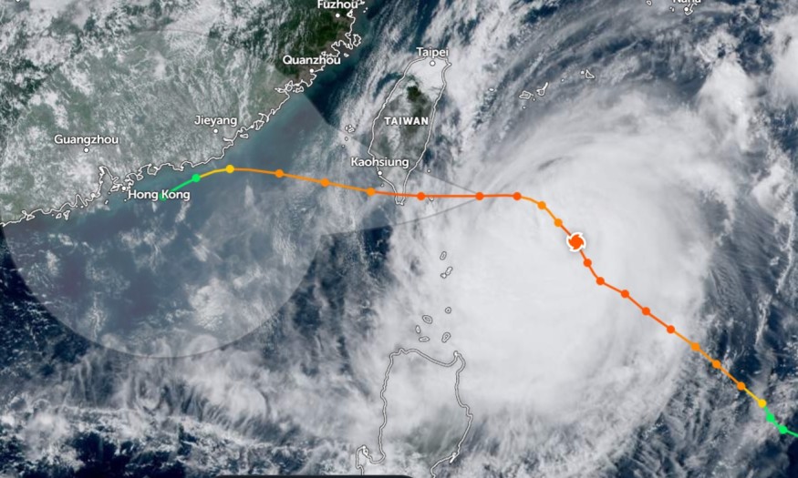
Heavy rain conditions and damaging winds are expected in Southern Taiwan and Southeastern China in the midweek due to the rapid intensification of Typhoon Koinu.
The typhoon will make landfall near the Southeast Coast in Taiwan this Thursday. Residents can expect the brunt of the typhoon and flooding rainfall before the end of the week.
Homeowners with outdoor plans should check the weather forecasts and developments of Typhoon Koinu. The main concern of flooding could unfold on Thursday morning.
Typhoon Koinu: Where Will it Impact?

The latest weather report monitored the typhoon movement over 150 miles of Taiwan East. It is expected to impact southeastern portions of Taiwan on Thursday. Hongkong and Southeastern China can experience rainy conditions and challenging winds.
The forecast added that Koinu maintained significant maximum sustained winds of 115mph. The typhoon winds are equivalent to a Category 3 hurricane, according to the Saffir-Simpson Hurricane Wind Scale.
Taiwan and China are no strangers to extreme weather events. People should also watch out for potentially flooded roads in Southeastern portions of Taiwan. Rip currents and challenging waves are possible for people near the sea.
Furthermore, the typhoon intensified from being a low-pressure during the end of September. Strengthening typhoons can develop quickly, bringing severe weather impacts in Taiwan and China.
The typhoon can likely bring one to two inches of rain in Southwestern China and Northern Taiwan. However, there is a possibility that the storm could intensify.
Homeowners should also stay alert for damaging wind gusts from the typhoon. It is advisable to secure all outdoor items. Power outages are also possible.
Tips to Keep Safe From Typhoon Koinu This Week
The typhoon quickly intensified during the first week of October. The weather dangers are likely on Thursday morning. People with travel plans should better check the weather before going out.
Preparing for severe storms and typhoons is helpful, preventing potential significant damage to life and property. Here are essential reminders to stay safe from Typhoon Koinu.
1. Check the latest developments about Typhoon Koinu
Residents in the affected areas should monitor the weather developments, especially in Hong Kong, Taiwan, China and the Philippines. Understanding the weather impacts can help homes prepare better.
When the weather unleashes rapid flooding, homeowners should immediately evacuate into secure areas. Keep away from floodwater dangers, especially for children.
2. Anticipate power outages, strong winds and flooding
Before the end of the week, people should anticipate potential power outages, flooding and travel disruption. The strong winds can impact powerlines, causing widespread power outages.
In addition, it is recommended to keep a battery-powered flashlight and a small radio.
3. Keep emergency home kits and supplies for typhoons
It is essential that the home should store emergency kits or supplies. It can help during natural disasters, including typhoons.
Related Article : Deadly Tornado in China Update: 10 People Killed; 137 Houses Collapsed While 5,500 Affected
For more similar stories, don't forget to follow Nature World News.
© 2025 NatureWorldNews.com All rights reserved. Do not reproduce without permission.


