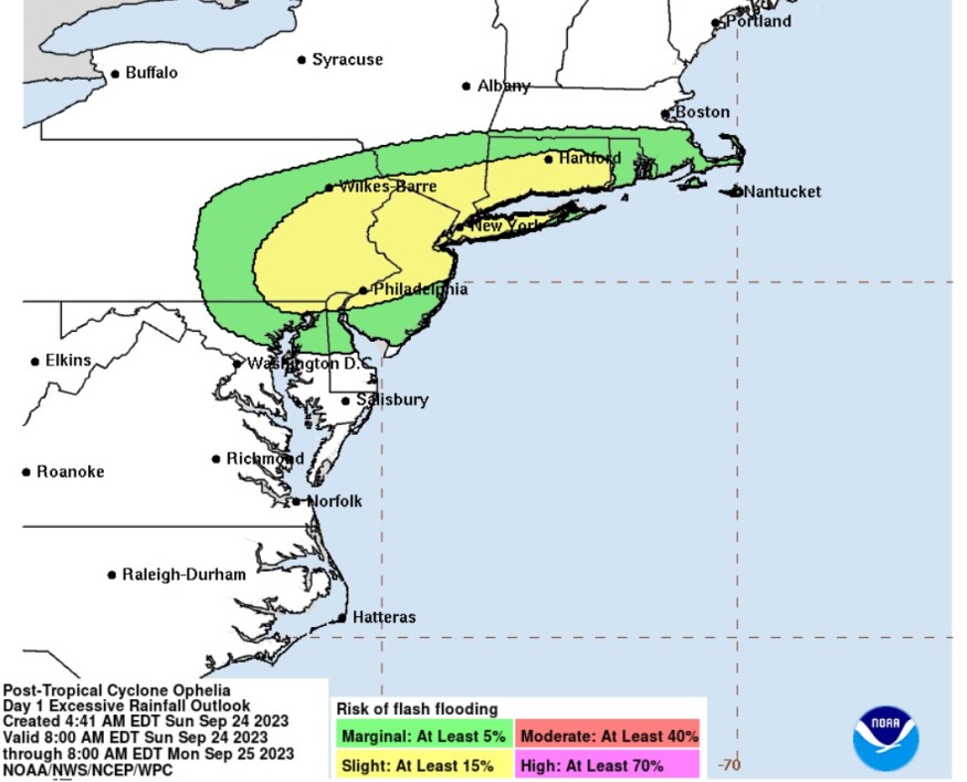
Weather disturbance Ophelia brought havoc in some parts of the United States' East coast, bringing inundation and power outages.

Meteorologists said that around 30,000 customers have been cut out with electric supply due to Ophelia's powerful winds. They said that wind gusts as high as 80 miles per hour have been experienced by residents in Wrightsville Beach, North Carolina.
In its landfall in North Carolina, Ophelia unleashed torrential rains that also resulted in massive floods from eastern North Carolina to southern New Hampshire.
Officials said that Pennsylvania was on top of the list of affected areas of Ophelia.
Ophelia's track
The National Hurricane Center and Central Pacific Hurricane Center said that at 500 AM EDT (0900 UTC), the center of Ophelia, now categorized as post-tropical cyclone, was located near latitude 37.7 North, longitude 77.3 West.
The post-tropical cyclone is seen tracking the direction toward the north-northeast near 12 mph (19 km/h) and this motion is expected to continue before making a turn to the east.
Maximum sustained winds are near 25 mph (35 km/h) with higher gusts. Weather experts also see a gradual weakening of Ophelia during the next 48 hours as the low center moves slowly offshore.
On the other hand, the estimated minimum central pressure is forecasted at 1007 mb (29.74 inches).
When it comes to storm surge, water levels remain elevated within some of the areas in Chesapeake Bay and its tidal rivers, however, it is seen to gradually recede through today.
Ophelia is also expected to unleash more rainfall in some areas including the portions of the Mid-Atlantic to southern New England, with one to three inches of rain. This amount of rainfall may produce localized flash, urban, and small stream flooding impacts across portions of the Mid-Atlantic region into southern New England.
Moreover, isolated river flooding is possible in areas where heavier rainfall could be experienced.
The swells that were generated by Ophelia would also continue to affect much of the east coast of the United States. These swells are likely to cause life-threatening surf and rip current conditions.
Residents are urged to check information specific as regards to their locations from their respective local National Weather Service forecast office.
Floods, rescue efforts
Ophelia was a strong tropical storm, packing maximum sustained winds of 70 mph, when it made landfall.
Officials said a number of individuals had to be rescued due to the dangerous seas that was triggered by Ophelia even as it approached the land area.
There were dangerous episodes of flash flooding, including that of Greenville, North Carolina wherein it endured a "major flash flood event" over the weekend.
Risky sea conditions also led to problems, with authorities rescuing five individuals from a boat that was anchored near the North Carolina coast before the weekend.
Storm surge floods also inundated some communities, bringing knee-high water in many homes along the waterfront in New Bern, North Carolina.
Ophelia also unleashed a formidable force in parts of the Outer Banks.
Due to these conditions, authorities were forced to declare a state of emergency in North Carolina, Virginia and Maryland.
Related Article : Tropical Storm Warnings in US: Heavy Rain, Flash Flood Risks Likely in New Jersey, Southeastern Virginia, Mid-Atlantic States
Related Video:
© 2025 NatureWorldNews.com All rights reserved. Do not reproduce without permission.


