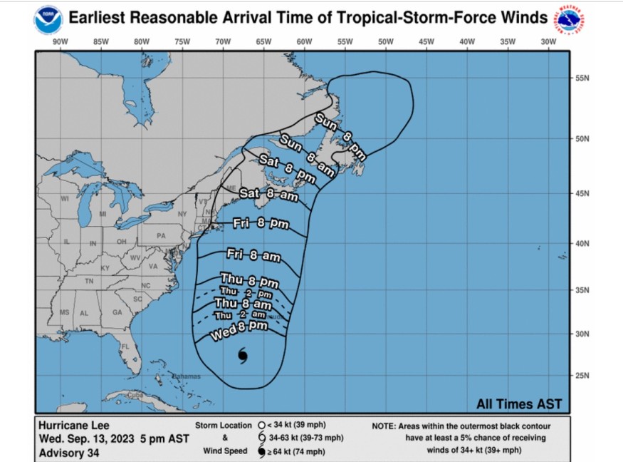
Weather experts said that Hurricane Lee is forecasted to make its landfall over Maine and Canadian Maritimes.
Inundation, powerful winds, and risky surfs are expected to be experienced across New England through much of the Canadian Maritimes as Lee is seen to pound through the region.

Meteorologists said that Lee was making a critical turn towards the north over the Atlantic on Wednesday as they warned for the storm's arrival from eastern New England to New Brunswick and Nova Scotia.
Lee, currently at Category 2, will bring strong winds and may cause coastal floodings and storm surges over the eastern New England and the Canadian Maritimes this weekend.
Due to this, cut of power supply and tree damage are very possible. Some roads can also be blocked with floods, uprooted trees and debris.
Read Also : Hurricane Lee: Nova Scotia Warned Over Powerful Winds, Floods; Impact Still Seen In Atlantic Canada
Weather track
The National Hurricane Center and Central Pacific Hurricane Center said that at around 800 PM AST (0000 UTC), the eye of Hurricane Lee was spotted by meteorologists from the National Oceanic and Atmospheric Administration and the Air Force Hurricane Hunter aircraft near latitude 27.6 North, longitude 67.7 West.
So far, Lee is tracking the direction towards north-northwest near 9 mph (15 km/h).
Weather experts said that a motion gearing towards the north as well as an increase in forward speed are expected through Friday.
Based on Lee's forecasted track, its center will pass west of Bermuda on Thursday and Thursday night as it will approach the coast of New England and Atlantic Canada either by Friday or Saturday.
Hurricane conditions are possible in portions of down-east Maine on Saturday.
Tropical storm conditions are also seen to hit in portions of coastal New England within the tropical storm watch area beginning Friday night.
Lee's maximum sustained winds are near 105 mph (165 km/h), packing higher gusts. It is expected to slowly weaken in the coming days; but, Lee is still likely to remain a very large and dangerous hurricane over the weekend, with adverse impacts expected.
Dubbed as a very large hurricane, Lee's hurricane-force winds extend outward up to 115 miles (185 km) from the center and tropical-storm-force winds extend outward up to 265 miles (425 km).
Meanwhile, the minimum central pressure reported by the Hurricane Hunter aircraft is 951 mb (28.08 inches).
The swells caused by Lee are affecting portions of the Lesser Antilles, the British and US Virgin Islands, Puerto Rico, Hispaniola, the Turks and Caicos Islands, the Bahamas, Bermuda, and the east coast of the United States.
These swells also begin to reach Atlantic Canada.
Hurricane watch, tropical storm warnings
Following the foreseen impacts of Lee, a hurricane watch has been raised over Stonington, ME to the US/Canada border, meteorologists said.
They added that a tropical storm warning is also in effect in Bermuda.
Meanwhile, a tropical storm watch has been placed over areas such as Watch Hill, RI to Stonington, ME; Block Island; Martha's Vineyard; and Nantucket.
On the other hand, a storm surge watch is in effect for Cape Cod Bay and Nantucket
According to the NOAA, a hurricane watch means that hurricane conditions are possible within the watch area, and that it is typically issued 48 hours before the anticipated first occurrence of tropical-storm-force winds, or the conditions that make outside preparations risky or hard.
On the other hand, a tropical storm warning is described as tropical storm conditions that are expected somewhere within the warning area, in this case within the next 24 hours, while the tropical storm watch means that tropical storm conditions are possible within the watch area, generally within 48 hours.
Meanwhile, a storm surge watch means that there is a possibility of life-threatening floods due to the rising water that is moving inland from the coastline in the indicated locations during the next 48 hours.
Related Article : Hurricane Lee at Category 3: New England, Atlantic Canada Brace for Damaging Winds
Related Video:
© 2025 NatureWorldNews.com All rights reserved. Do not reproduce without permission.


