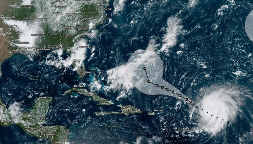
Due to Hurricane Lee's projected five-day stay in the US at Category 3, experts caution that coastal erosion may occur.
Category 3 Hurricane Lee
Although Hurricane Lee has been downgraded to a Category 3, forecasters believe it could strengthen over the weekend and into next week. Prior to that, .Hurricane Lee blasted into a potent Category 5 storm within 24 hours as it raced across the wide Atlantic Ocean.
11AM AST Sep 9: @NOAA_HurrHunter & @53rdWRS find #Lee maintaining strength this morning. Hazardous beach conditions are expected around the western Atlantic through next week. Visit https://t.co/tW4KeGe9uJ for the latest information pic.twitter.com/xXiy8NY8Ux
— National Hurricane Center (@NHC_Atlantic) September 9, 2023
Although it may be a severe storm for not less than the next five days, it is still too early to predict whether it will have any effects on the US Atlantic coast. The center warned that the next week could "worsen" the potentially hazardous surf and rip currents that are anticipated for Sunday and Monday.
At its closest point to the northern Leeward Islands, Lee was about 400 miles east-northeast of them as of Saturday, with winds that might reach 115 mph.
Forecasters predict that the hurricane will pass north of Puerto Rico, the Virgin Islands, and the northern Leeward Islands, but the British and US Virgin Islands, Hispaniola, Puerto Rico, the Turks and Caicos Islands, the Bahamas, and Bermuda may experience life-threatening surf and rip conditions as a result of the hurricane.
Hazardous Conditions
According to the Hurricane Center, Lee is now heading toward the west-northwest at a pace of about 12 mph. This motion is anticipated to last through early next week before drastically slowing down later tonight and on Sunday. Through the following week, dangerous beach conditions are anticipated to develop in the western Atlantic.
The storm will similarly affect Caribbean islands as it slowly progresses west-northwest into the Atlantic. According to forecasters, Lee is anticipated to pass "well to the north" of Puerto Rico, the Virgin Islands, and the northern Leeward Islands.
Swells, Coastal Erosion, and Flooding
The Lesser Antilles are being affected by Hurricane Lee's surges, the storm center warned Friday night. This weekend's swells could bring dangerous surf and rip conditions.
In San Juan, Puerto Rico, the National Weather Service reported that 6 to 10-foot waves were expected to breach on Sunday. Next week, larger waves were anticipated on beaches facing east and north.
The company warned of the possibility of coastal flooding and beach erosion on their social media accounts.
Also Read : Severe Thunderstorms Could End Prolonged Heat, Fall-Like Conditions Might Finally Arrive in Midwest US
Hurricanes
Warm ocean, moist air, and light upper-level winds are the ideal conditions for hurricanes to intensify up to Category 5 strength.
David Zierden, Florida's state climatologist, reports that sea-surface temperatures over the area of the Atlantic Ocean that Lee is moving through are a startling 3.6 degrees Fahrenheit above average after rising to "far above record levels" this summer.
Over the past ten years, reaching Category 5 strength has become more frequent. Lee is the eighth Category 5 hurricane to hit since 2016, which means that 20% of the most intense hurricanes ever recorded in NOAA's hurricane database have occurred in the previous seven years. Hurricane Lee has since been downgraded to Category 3.
Related Article : Death Valley Closed as Hilary Aftermath Left Extensive Damages, Turning Driest Park Into Wet Fragile Landscape
© 2025 NatureWorldNews.com All rights reserved. Do not reproduce without permission.


