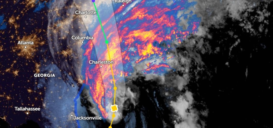
Hurricane Ian is expected to hit South Carolina and Georgia, which may cause life-threatening flooding, storm surge, and strong winds, the NOAA NWS National Hurricane Center announced in the latest advisory.
According to NOAA NWS National Hurricane Center, Hurricane Ian will approach South Carolina Friday night and Saturday.
Areas in Georgia and Florida will also be affected, and residents are urged to follow the announcement from local officials.
Moreover, Hurricane Ian is forecasted to strengthen slightly and rapidly weaken on Friday into Saturday.
Here are the 11 PM EDT Sep 29 Key Messages for Hurricane #Ian, which is expected to cause life-threatening flooding, storm surge, and strong winds in portions of the Carolinas tomorrow. For more: https://t.co/tW4KeFW0gB pic.twitter.com/rXQdc8Mb3A
— National Hurricane Center (@NHC_Atlantic) September 30, 2022
The advisory said that the center of Hurricane Ian was seen at about 240 miles south of Charleston, South Carolina.
NOAA Hurricane Center noted that the Hurricane had 75 mph (120 km/h) maximum sustained winds with higher gusts.
The Hurricane track moves north-northeast at ten mph (17 km/h).
Hurricane Ian Advisories

The NHC further advised in the key messages announcements to remind residents of the potential threat of intensified Hurricane Ian. According to the information:
- Starting early Friday, Southeastern North Carolina and the coasts of South Carolina will experience hurricane-force winds. NHC said that Hurricane Warning and Watch are in effect.
- South Carolina, North Carolina, and Southern Virginia could experience flooding through Friday.
- Hurricane Ian will cause river flooding in portions of Central Florida that may persist through next week.
In the current advisory, NHC recorded an estimated minimum central pressure of 986 mb (29.12 inches).
For updated weather advisories, visit the National Hurricane Center (NHC) website.
On the other hand, AccuWeather said that Hurricane Ian's impact through Sunday included:
- Rainfall flooding
- Dangerous seas
- Coastal inundation
- Power outages
- Destructive winds
- Isolated Tornadoes
According to the weather website, AccuWeather noted the following areas that Hurricane Ian could affect: South Carolina, Charleston, Myrtle Beach, Wilmington, South Carolina Coasts, Georgia, Augusta, Columbia, Charlotte, Raleigh, Greensboro, and Virginia.
Furthermore, Florida Governor Ron DeSantis urged residents to be careful with downed power lines and trees.
Safety during Hurricane Ian threat
Hurricane Ian can threaten lives and property.
Despite it weakening, it managed to restrengthen to a Hurricane again.
Forecasts of affected communities are advised to watch for flooding risks, flash flooding, landslides, and coastal inundation. Here are some preparation reminders for Hurricane Ian.
- Reports revealed that Hurricane Ian would continue to unleash heavy rains this week with rising sea water levels. The strong winds coming from the Hurricane could turn down trees and power lines. Refrain from traveling to areas with Hurricane Warnings and Watch.
- Always check your equipment and property for potential damage, especially electrical power outages and leaks.
- Stay updated with the current news and weather updates from local and national announcements-full-charge mobile phones or any gadgets in case of power interruptions.
- Keep a supply of food during the impact of Hurricane Ian. It is best to keep an emergency bag with you in cases of evacuation.
- After the Hurricane threat, repair damages sustained from the Hurricane.
- If you plan to return to your house, keep watch for falling debris and flooded areas with downed power lines.
For more similar stories, don't forget to follow Nature World News.
© 2025 NatureWorldNews.com All rights reserved. Do not reproduce without permission.


