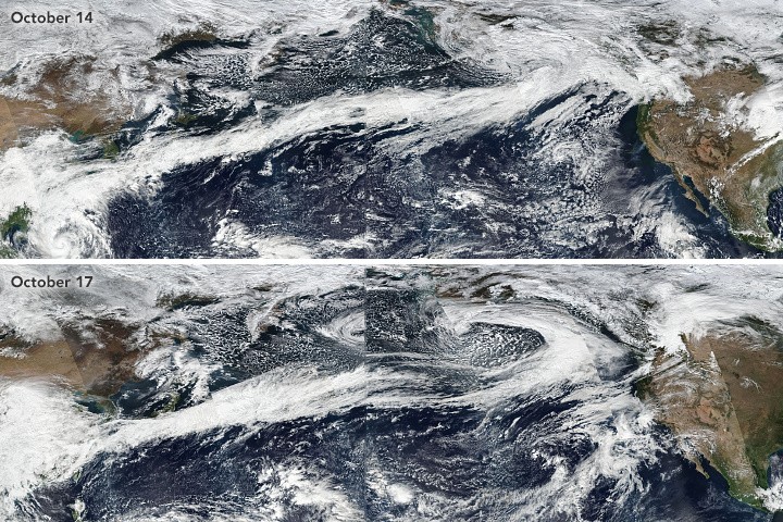
A late-season atmospheric river is headed toward the Pacific Northwest and British Columbia, Canada. AccuWeather meteorologists warn it may produce catastrophic flooding if it reaches land in the coming days.

Extreme Weather
Storms continue to come in from the Pacific Ocean, trapping most of western Washington and southern British Columbia in the grip of winter. Many sites received two to three times their typical rainfall in May, and most have already received nearly all of their monthly rainfall for June in the first week.
According to experts, storms over the northern Pacific Ocean aren't common this late season. However, more storms are forming and could cause a fire hose effect of torrential rain later this week across the northwest United States and southern Canada. Last November, an even greater atmospheric river crashed into these locations, causing a catastrophic and terrible disaster.
In May, 3.82 inches of rain fell in Seattle, compared to 1.88 inches on average for the month. 1.03 inches of rain fell in the first seven days of June, compared to 1.45 inches for the entire month in the city. In Vancouver, British Columbia, 3.45 inches (87.6 mm) of rain fell in May, 2.2 times the typical amount, and 1.18 inches (30.0 mm) fell from June 1-7, which is already two-thirds of the average for the whole month.
The persistence of storms from the Pacific, which generally pack their bags and leave for the summer season, has been a concern this spring, although the rain levels have not been spectacular. The dry season in the region runs from late May to the first half of September, with only occasional rainfall of approximately an inch per month for the coastal lowlands and somewhat larger quantities for the western slopes of the mountains.
Dry weather helped lay the setting for all-time high temperatures in areas of the region last spring. This spring, the earth is fairly damp, leading to a new problem in some areas.
Warmer air contributes to a slow disintegration of the snowpack at intermediate elevations between 4,000 and 8,000 feet in the absence of moisture-laden storm systems during a regular summer season.
Following the Atmospheric River
However, if storms with heavy rain persist until the first half of the summer, the remaining snow cover might liquefy, resulting in a quick runoff that could cause deadly and destructive flash floods.
AccuWeather meteorologists have been following an atmospheric river capable of triggering that problem for several days. According to Senior Meteorologist Mike Doll, a succession of powerful storms and a plume of moisture stretch hundreds of kilometers from waters east of Asia to the south of Alaska's Aleutian Islands.
Warm, moist air and heavy rain are en route to southwestern British Columbia and western Washington, with the effects anticipated to be felt primarily from Thursday to early Friday.
According to Meteorologist Alyssa Smithmyer, the rain will come in waves throughout the weekend.
"The dose shortly before the end of the week," Smithmyer added, "may cause enormous issues in rapid melting at intermediate levels and rapid flooding of the streams and rivers that run through and out of the mountains down below."
Near sea level, 1-2 inches of rain is expected, but 2-4 inches is more likely, with local amounts up to 6 inches possible on the west-facing mountain slopes. This quantity of rain would not be enough to cause serious flooding issues, but the mountains are covered with snow.
According to forecasters, the snowfall is presently measured in yards at moderate and high elevations.
"The issue is that the snowpack temperature at intermediate elevations is near freezing and ready to melt," said Senior Storm Warning Meteorologist William Clark.
Many inches of water are trapped beneath that snowpack. When heavy rain falls on a melting snowpack, it can thaw quickly, effectively doubling or tripling rainfall quantities.
This design has the potential to inundate some highways and neighborhoods with quickly rising water. The scenario can be hazardous in areas where flash flooding occurs at night.
Forecasters predict that several minor roads and bridges may be washed out and that mud and other debris could obstruct some highways. Drivers who travel through flood-prone areas during significant rain events in the winter and spring should expect complications and be prepared to seek an alternate route.
November Atmospheric River
Last November, an atmospheric river dumped severe rains throughout British Columbia and parts of Washington. More than 20 inches of rain poured in some places, causing considerable damage to several roadways. Repair work is still underway in British Columbia, and employees may experience delays because of the atmospheric river. During the storms last autumn, all main highways and rail lines leading to Vancouver were stopped, and North America's third busiest port operations came to a standstill.
According to The Associated Press, one person was killed due to the storms in the Canadian province.
The floods of November 2021 caused billions of dollars in damage in Washington and Oregon. Seventy-five percent of the residences in Sumas, Washington, roughly 115 miles north of Seattle, were damaged by flooding.
Storm Forecast
Depending on the pace of the next storm, the second bout of rain will arrive from Friday night until Saturday. That storm did not look as powerful as the one on Thursday. However, the second storm this weekend may deliver some precipitation to the south, bringing showers to sections of Northern California.
According to meteorologists, while the storm train will deliver an abundance of rainfall to the Northwest over the weekend, the pattern will not bring significant rain to drought-stricken California and much of the southwestern United States.
Related Article : Exposure to Major Disasters Can Cause Long-Term Mental Health Problems
For more climate and weather updates, don't forget to follow Nature World News!
© 2025 NatureWorldNews.com All rights reserved. Do not reproduce without permission.


