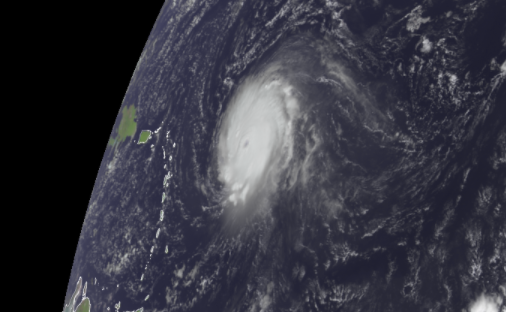
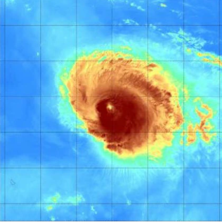
Hurricane Sam has produced some terrific satellite pictures throughout the course of its long existence. In addition, global satellites have offered a glimpse into the lifespan of a large tropical cyclone thousands of kilometers away at sea - one of Mother Nature's most powerful forces - from fast intensification through eyewall replacement cycles.

Sam got its name when it became a tropical storm on September 23. The storm surged in power not long after reaching that milestone, exhibiting what meteorologists' term "rapid intensification," a 24-hour rise in a storm's maximum sustained winds of 35 mph or more.
As a result, Sam was already a Category 1 hurricane on the Saffir-Simpson Hurricane Wind Scale less than 24 hours after receiving its name.
Intensifying hurricane
As the sun rises this morning, the #GOESEast 🛰️ is keeping watch on #HurricaneSam as it tracks northwestward over the Atlantic. With sustained wind speeds of 130 mph, #Sam is a major Category-4 #hurricane.
— NOAA Satellites (@NOAASatellites) September 27, 2021
Get the latest: https://t.co/1L8q1zxF6u pic.twitter.com/r96Wq5n3Yg
Sam swiftly intensified throughout the weekend, eventually peaking as a dangerously severe Category 4 hurricane with maximum sustained winds of about 150 mph on Sunday.
As a result, Sam came within a whisker of being the first storm of the season to reach Category 5 strength. A storm with sustained winds of 157 mph or higher is classified as Category 5.
By the end of the weekend, satellite footage had visibly verified Sam's intensity, with the storm having produced a clearly defined eye. The term "eye of the storm" is used by meteorologists to describe the lowest pressure region of a tropical cyclone. The eyewall, which runs outside the eye, is where the most turbulent circumstances occur.
Related Article : Meteorologists Predicts that the Atlantic Hurricane Season Will Inevitably Be More Aggressive
Eyewall Replacement Cycle
A powerful storm will go through what is known as an eyewall replacement cycle during its existence. This procedure will take place primarily to stabilize the hurricane's center.
An eyewall replacement cycle may frequently result in the storm losing some wind intensity and even being demoted to a lesser category due to the procedure. This is precisely what happened earlier this week with Hurricane Sam. Sam remained a strong storm during its eyewall replacement cycle, although it weakened significantly to Category 3 on Monday.
"Re-Intensified"

Sam re-intensified into a Category 4 hurricane when the new eyewall was finished. After that, Sam might intensify enough to make a run at a Category 5 hurricane designation, according to forecasts, but the window for that possibility was fast shrinking.
Apart from being a vast storm, Sam's long trip across the ocean continues to add to the Atlantic basin and the Northern Hemisphere's Accumulated Cyclone Energy (ACE).
According to Colorado State University, the cumulative ACE for the Atlantic basin was up to 105.2 as of September 28. The long-lived Hurricane Larry was the storm that has generated the highest ACE so far this season. Given Sam's predicted trajectory and strength, analysts believe the hurricane may overtake Larry for the top place as early as October 1.
The powerful hurricane has stayed well distant from any potential landfall. This has allowed weather aficionados and even casual viewers to admire the inherent beauty of one of the planet's most powerful natural phenomena.
For more climate and weather updates, don't forget to follow Nature World News!
© 2025 NatureWorldNews.com All rights reserved. Do not reproduce without permission.


