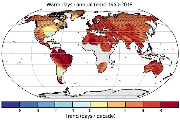
A major global update based on data from more than 36,000 weather stations around the world confirms that, as the planet continues to warm, extreme weather events such as heatwaves and heavy rainfall are now more frequent, more intense, and longer.
The research is based on a dataset known as HadEX and analyses 29 indices of weather extremes, including the number of days above 25℃ or below 0℃, and consecutive dry days with less than 1mm of rain. This latest update compares the three decades between 1981 and 2010 to the 30 years prior, between 1951 and 1980.
Globally, the clearest index shows an increase in the number of above-average warm days.

For Australia, the team found a country-wide increase in warm temperature extremes and heatwaves and a decrease in most areas in cold temperature extremes such as the coldest nights. Broadly speaking, rainfall extremes have increased in the west and decreased in the east, but trends vary by season.
In New Zealand, temperate regions experience significantly more summer days and northern parts of the country are now frost-free.
Extreme temperatures
Unusually warm days are becoming more common throughout Australia. When we compare 1981-2010 with 1951-80, the increase is substantial: more than 20 days per year in the far north of Australia, and at least 10 days per year in most areas apart from the south coast. The increase occurs in all seasons but is largest in spring.
This increase in temperature extremes can have devastating impacts for human health, particularly for older people and those with pre-existing medical conditions. Excessive heat is not only an issue for people living in cities but also for rural communities that have already been exposed to days with temperatures above 50℃.
New Zealanders are also experiencing more days with temperatures of 25℃ or more. The climate stations show the frequency of unusually warm days has increased from 8% to 12% from 1950 to 2018, with an average of 19 to 24 days a year above 25℃ across the country. Unusually warm days, defined as days in the top 10% of historic records for the time of year, are also becoming more common in both countries.
During the summers of 2017-18 and 2018-19, marine heatwaves delivered 32 and 26 (respectively) days above 25℃ nationwide in New Zealand, well above the average of 20 days. This led to accelerated glacial melting in the Southern Alps and major disruption to marine ecosystems, with die-offs of bull kelp around the South Island coast and salmon in aquaculture farms in the Marlborough Sounds.
More heat, more rain, less frost
In many parts of New Zealand, cold extremes are changing faster than warm extremes.
Between 1950 and 2018, frost days (days below 0℃) have declined across New Zealand, particularly in northern parts of the country which has now become frost-free, enabling farmers to grow subtropical pasture grasses. At the same time, crops that require winter frosts to set fruit are no longer successful, or can only be grown with chemical treatments (currently under review) that simulate winter chilling.
Across New Zealand, the heat available for crop growth during the growing season is increasing, which means wine growers have to shift varieties further south.
In Australia, the situation is more complicated. In many parts of northern and eastern Australia, there has also been a large decrease in the number of cold nights. But in parts of southeast and southwest Australia, frost frequency has stabilised, or even increased in places, since the 1980s.
These areas have seen a large decrease in winter rainfall in recent decades. The higher number of dry, clear nights in winter, favourable for frost formation, has cancelled out the broader warming trend.
In Australia, extreme rainfall has become more frequent in many parts of northern and western Australia, especially the northwest, which has become wetter since the 1960s. In eastern and southern Australia the picture is more mixed, with little change in the number of days with 10mm or more of rain, even in those regions where total rainfall has declined.
In New Zealand, more extremely wet days contribute towards the annual rainfall total in the east of the North Island, with a smaller increase in the west and south of the South Island. For Australia, there are significant drying trends in parts of the southwest and northeast, but little change elsewhere.
Extremes of temperature and precipitation can have dramatic effects, as seen during two marine heatwaves in New Zealand and the hottest, driest year in Australia during 2019.
This article is republished from The Conversation under a Creative Commons license. Read the original article. | Jim Salinger, Honorary Associate, Tasmanian Institute for Agriculture, University of Tasmania and Lisa Alexander, Chief Investigator ARC Centre of Excellence for Climate System Science and Associate Professor Climate Change Research Centre, UNSW
© 2025 NatureWorldNews.com All rights reserved. Do not reproduce without permission.


