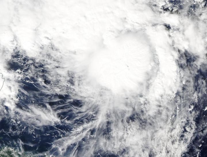
On Nov. 20, the Moderate Resolution Imaging Spectroradiometer or MODIS instrument that flies aboard NASA's Aqua satellite provided a visible image on Fung-Wong. The image indicated that the circulation center was more well-defined. A band of thunderstorms was also seen on the eastern side of the storm.
The shape of the storm is a clue to forecasters that a storm is either strengthening or weakening. If a storm takes on a more rounded shape it is getting more organized and strengthening. Conversely, if it becomes less rounded or elongated, it is a sign the storm is weakening. Fung-Wong has appeared to become more symmetrical in the MODIS imagery, indicating it is getting better organized.
In addition, the Joint Typhoon Warning Center noted that animated enhanced infrared satellite imagery suggests the low-level circulation center is obscured under central dense overcast. The deep convection (bands of thunderstorms) appears to have begun wrapping completely around the low-level center of circulation.
At 10 a.m. EST (1500 UTC) on Nov. 20, the center of Tropical Storm Fung-Wong was located near latitude 19.5 degrees north and longitude 126.4 degrees east. That puts the center about 432 nautical miles southeast of Taipei, Taiwan. Maximum sustained winds were near 45 knots (52 mph/83 kph). Fung-Wong is moving to the north-northwest.
The Joint Typhoon Warning Center or JTWC noted that Fung-Wong would move northwest toward Taiwan. The system is forecast to strengthen to 55 knots (63 mph/102 kph) within 24 hours before weakening rapidly on approach to Taiwan.
The Central Weather Bureau of Taiwan is keeping track of the storm and will provide watches and warnings.
Typhoons and hurricanes are the most powerful weather event on Earth. NASA's expertise in space and scientific exploration contributes to essential services provided to the American people by other federal agencies, such as hurricane weather forecasting.
© 2025 NatureWorldNews.com All rights reserved. Do not reproduce without permission.


