Mid-Atlantic can experience potential severe storms, causing damaging winds, hail conditions, and travel dangers. A chance of isolated tornadoes is likely, including flash flood threats.
People traveling in parts of the Mid-Atlantic should keep updated with the latest weather reports due to a developing severe thunderstorm. The poor weather conditions can lead to slower commutes and power outages.
In the latest advisory, the National Weather Service (NWS) reports an enhanced risk for severe thunderstorms, which can unleash potential severe hail and tornado concerns. The possible weather risk can occur in northern Missouri and west-central Illinois. However, homeowners should also keep updated with elevated critical fire conditions in the southern High Plains.
The weather advisory reminds residents to stay prepared for nighttime tornadoes by turning on mobile emergency alerts or NOAA weather radio. The beginning of April brought challenging weather outlooks in parts of the Southern, Northeast, and Mid-Atlantic US.
Mid-Atlantic Severe Weather Forecast: Where Will Stormy Conditions Unload?

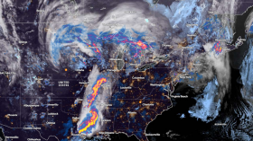
(Photo : Zoom Earth Satellite via NOAA NESDIS)
The latest weather report reveals that stormy conditions can occur from Ohio to Pennsylvania, with wind gusts reaching 60 mph. Homeowners should stay alert for possible power outages due to the weather, including hail conditions.
NWs issued a Severe Thunderstorm Watch in parts of Mid-Alantic, warning of large and damaging hail. People with outdoor plans should limit any activities due to potential exposure to severe weather in the region.
In the Central US, the advisory raises concerns about the severe weather from April 15 to April 16. Residents can expect scattered severe thunderstorms from the southern to central Great Plains. The forecast warns of the primary risks of isolated tornadoes. NWS monitors the development of an active spring severe weather pattern.
In the early week, the severe thunderstorms can threaten the following areas:
- Lexington
- Charleston
- Kingsport
- Danville
- Roanoke
- Charlotteville
- Washington
- Richmond
- Hampton
- Central Kentucky
In addition, portions of the northern tier of North Carolina can experience challenging weather conditions. On Tuesday, the weather pattern can change into a rainy outlook in Charleston, Columbus, Pittsburgh, Detroit, and Virginia Beach.
In Pittsburgh, the latest report reveals that warm highs can unfold on Tuesday. The advisory advises people to immediately seek shelter in homes or buildings when severe thunderstorms occur.
Also Read: Colorado, Kansas Weather Forecast: NWS Warns of Critical Risk of Fire This Week
Staying Safe from Large Hail and Tornado Threats
Due to the possible threats of tornadoes and large hail, homeowners should keep updated with the latest forecasts this week, to stay safe from hazardous weather. When tornadoes occur, evacuating into secure areas is important, and it is best to keep away from windows, doors, trees, and power lines.
Traveling this week could be hazardous in the affected areas due to a severe weather threat. Limiting outdoor plans is advisable, especially when commutes are not necessary.
Related Article: Midwest, Central US Weather Forecast: Stormy Conditions to Bring to Bring Strong Winds, Thunderstorms
For more similar stories, don't forget to follow Nature World News.
© 2024 NatureWorldNews.com All rights reserved. Do not reproduce without permission.


![Climate Change is Reducing Dust Levels Worldwide as Arctic Temperature Warms [Study]](https://1471793142.rsc.cdn77.org/data/thumbs/full/70320/280/157/50/40/climate-change-is-reducing-dust-levels-worldwide-as-arctic-temperature-warms-study.jpg)