(Photo : Photo by Justin Sullivan/Getty Images)
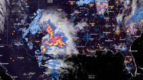
Avalanche and flood warnings persist in the Pacific Northwest over the next days as an 'extreme' atmospheric river was forecasted in the region. The tropical plume is expected to produce periods of moderate to heavy rain beginning the workweek.
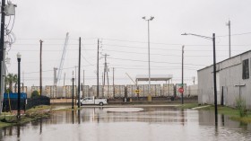
"Flood watches and warnings were in place Monday for over five million people across Idaho, Oregon and Washington, including Seattle," CNN reported. "As of Monday afternoon, Seattle had received more than three and a half inches of rain in just 48 hours."
According to the National Weather Service (NWS) Seattle, the rainfall on Monday alone made the day "the fourth-wettest February day on record."
"As of 4:30 PM, Seattle rainfall since midnight now stands at 2.33 inches. That's already good enough for the 4th wettest February day on record," the service tweeted. "First place...at least, for now...is occupied by Feb 8th, 1996 with 3.06"."
Avalanche warnings across northwest regions
The Northwest Avalanche Center forecasted a natural avalanche cycle on Monday, March 1, which can lead to human-triggered avalanches on Tuesday. While this likelihood will continue to slowly decrease, it is likely that a large avalanche can be triggered on steep, unsupported slopes.
In addition, the center reports that the avalanche conditions may gradually improve should the temperatures cool and shower eases. "This won't be the day to try to tiptoe around the hazard," the center warns.
As the extreme Level 4 out of 5 atmospheric river brings heavy snow to the Cascades, an additional 2 to 4 inches of snow is forecasted through midweek. Although an atmospheric river to the scale of "extreme" is characterized by "mostly hazardous", the Center for Western Water and Weather Extremes say it could also be "beneficial" in terms of the amount of rain it yields.
Rain water draining into the snow decreases its strength in cases of avalanche, or "wet" avalanche to be precise. However, heavy rain and snow melt do lead to flooding.
Also read: U.N. Climate Change Report Shows Impacts are Larger than What Humans can Adapt
High threat for avalanches as temperature warms
Avalanche warnings have been issued for almost all zones forecasted by the Northwest Avalanche Center. The Washington Cascades, from the Canadian border south to the Columbia River were under avalanche warnings through 6 PM.
"Widespread avalanches large enough to bury and kill you are expected at Snoqualmie Pass on Monday," the avalanche center said. They warn not to travel in avalanche terrains where avalanches can start, run, or stop. The "large" ones could run a very long distance, all the way to the valley bottoms with "with and destructive debris."
Moreover, the center warns that flood could linger for much of the week as heavy rain and snow melt is expected to happen.
"Increased runoff from some [snow] melt will act as an addition to the rain-rates bringing potential for higher-than-normal runoff and flooding conditions," the Weather Prediction Center said.
Several rivers across Washington are forecast to reach moderate to major flood stage this week, while most area rivers off the Cascades will likely reach minor flood stage Monday night into Tuesday, "with moderate river flooding possible on the Skokomish, Snoqualmie, Nisqually and Cowlitz," NWS Seattle said.
The atmospheric river event is forecast to wane by Wednesday, with remaining snow and rain showers.
Also read: Indian Infrastructures to Replace 70% of Sand in Concrete with Shredded Plastic
© 2024 NatureWorldNews.com All rights reserved. Do not reproduce without permission.

![Venomous Centipede Could be Game-Changer and Save Lives of People with Kidney Disease [Study]](https://1471793142.rsc.cdn77.org/data/thumbs/full/70407/280/157/50/40/venomous-centipede-could-be-game-changer-and-save-lives-of-people-with-kidney-disease-study.jpg)