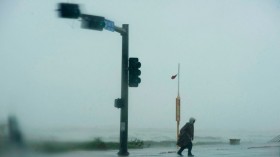
A weather report says challenging weather conditions are expected in the central U.S. this weekend. Potential isolated tornadoes and heavy downpours will likely cause power outages and hazardous road conditions.
According to an NWS Storm Prediction Center report, active severe weather will likely impact from Monday to Wednesday. The poor weather outlook can threaten portions of the southern and central Plains, including Arklatex, the lower Missouri Valley, and the Midwest.
Additionally, the weather advisory warns of a multi-day severe weather outlook with potential tornadoes and very large hail. People with outdoor plans should monitor the forecasts, especially tornado advisories.
Severe Weather in the Central U.S. This Weekend

(Photo : Zoom Earth Satellite via NOAA - NESDIS)
The latest weather forecast shows that severe thunderstorms can unload on the weekend. The stormy conditions can lead to travel delays, flash floods, and downpours.
This weekend, in a weather report, heavy thunderstorms are likely in the following areas:
- Wichita
- Springfield
- Oklahoma City
- Amarillo
- Lubbock
- San Angelo
- College Station
- Dallas
- Shreveport
- Little Rock
- Springfield
Additionally, the National Weather Service (NWS) warns of scattered severe thunderstorms in the southern High Plains into the Hill Country of Central Texas.
Meanwhile, east and southeast Texas can expect significant river flooding concerns, with possible moderate to major flooding risks. Communities in flood-prone or with poor drainage systems are vulnerable to flooding.
Weather Outlook in Plains
In the Plains, the latest forecast reveals that high wind conditions can impact portions of the interior West and High Plains. The strong winds can likely result in the blowing of dust, fire risks, and hazardous travel.
Additionally, homeowners should keep alert for potential power outages due to the weather outlook. Next week, a windy outlook, reaching from 60 to 80 mph, can occur in the following areas:
- Reno
- Elko
- Salt Lake City
- Las Vegas
- Flagstaff
- Denver
- Cheyenne
- Casper
- Billings
- Rapid City
- Fargo
- Grand Island
- Wichita
- Albuquerque
Fire risks, exacerbated by low relative humidity and dry areas, can unfold in Pueblo, Amarillo, El Paso, and Albuquerque. NWS Albuquerque warns of a dangerous fire weather outlook in the region due to strong southwest winds. Homeowners should limit outdoor burning or grilling, which can lead to fire spread.
In Little Rock, the advisory reveals that scattered to strong thunderstorms can occur in the area, with hail risk.
Also Read: Ohio Valley, Mid-Atlantic Forecast: Wetter Weather Pattern to Cause Slower Commutes This Week
Severe Thunderstorm Preparedness to Avoid Potential Dangers
The forecast warns of severe thunderstorms in the central U.S. this weekend. Travel conditions can be challenging in affected parts, so people should limit outdoor plans.
Additionally, people should store emergency or supply kits, which are helpful in emergency situations. The recommended kits are the following:
- Battery-powered radio
- Canned goods
- Bottled water supplies
- Flashlights
- Small radio
- Extra clothes
- Medicine kits
Related Article: Central US Weather Forecast: Severe Storms Likely to Bring Isolated Tornadoes This Weekend
For more similar stories, don't forget to follow Nature World News.
© 2024 NatureWorldNews.com All rights reserved. Do not reproduce without permission.