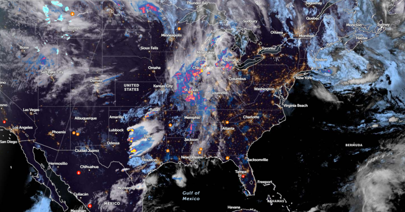
Mid-Atlantic and Ohio Valley can experience a wetter weather outlook this week, according to a National Weather Service (NWS) report on May 2. Commuters can expect slower travel due to the rainy outlook.
In the Pacific Northwest and northern California, outdoor enthusiasts can anticipate a strong cold front, with a chance of widespread heavy precipitation and late-season mountain snow.
Additionally, an active weather pattern can unload in the Central to Southern Plains, with additional severe weather, flash floods, and heavy rains.
Ohio Valley and Mid-Atlantic Weather Outlook

As reported by the NWS short-range forecast discussion, a wetter weather outlook can unload in Ohio Valley and the Mid-Atlantic.
In the Ohio Valley, relief is underway due to the recent dry weather outlook in the region. On Thursday, record-high temperatures can occur. The forecast added that cooler temperatures are likely this weekend in the Northeast and Mid-Atlantic.
In the late week, potential rainfall and blowing winds can unfold. For New York residents, the advisory reveals that high pressure can unload in New England on Friday, easing the dry conditions in the region. Temperatures can reach 50s and 60s.
In Boston City, potential showers and brief heavy downpours are possible, with a chance of small hail and thunderstorm conditions.
Additionally, a high-pressure system could unleash dry and warm conditions in Pittsburgh. Temperatures are expected to be above normal. According to a forecast, people at risk of hotter temperatures are older adults, children, newborns, pregnant women, and people with medical conditions.
NWS Miami reports that warm and dry weather can unload. Overnight lows can reach the mid-60s to low 70s. General minimal rainfall can also occur, including in parts of Florida.
In the Northeast, warm weather outlook can unload on Friday in the following areas:
- New York
- Washington
- Virginia Beach
- Charleston
On the weekend, potential rainy conditions can spread in the following areas:
- Boston
- New York
- Washington
- Charlotte
- Memphis
- Dallas
- Kansas City
- Chicago
- Houston
- Charlotte
- Jacksonville
As the Northeast encounters hotter temperatures, prolonged exposure to scorching heat is not advisable, particularly for vulnerable populations.
Weather in Other Parts of U.S: What Can People Expect?
The NWS advisory reveals that active spring weather is possible in the central U.S. Due to potential flooding and heavy rains, Flood watches are issued in parts of southern Oklahoma, eastern Texas, and northwest Louisiana.
Homeowners near flood-prone or poor drainage areas are vulnerable to flooding risks. Meanwhile, motorists should stay updated with the travel forecasts this week, particularly in portions of Texas and Oklahoma.
With looming tornadoes, keeping alert for tornado advisories is crucial to keep safe from dangerous situations. Limiting outdoor travel is the best option, particularly for vulnerable areas.
Related Article: US Severe Weather Forecast: Cleanup Underway After Tornado Outbreak from Great Plains to Midwest U.S.
For more similar stories, don't forget to follow Nature World News.
© 2024 NatureWorldNews.com All rights reserved. Do not reproduce without permission.


